


SENAT
Report n° 117 (2007-2008) by M. Roland COURTEAU, Senator (for the parliament office for the evaluation of scientific and technological choices) - Appendix to the minutes of the 7 December 2007 session
Disponible au format Acrobat (21 Moctets)
3. Unequal results
a) The Indian Ocean: a successful international mobilization effort
Following the Sumatra tsunami, the countries of the Indian Ocean touched by this natural disaster were the object of an unprecedented show of solidarity. The United States donated €1.95 billion, €714 million of which came from the government and €1.2 billion from private donators. Germany was the second largest contributor, with €536 million being donated by the German government and €553 million in private donations. In addition to donating money for humanitarian aid and the reconstruction of the devastated areas, numerous countries wanted to help set up a tsunami warning system for the Indian Ocean. As has already been pointed out, Germany committed €45 million to the installation of a warning system in Indonesia. Likewise, Japan has installed 23 wideband seismic stations in this country.
Since the tsunami warning system in the Indian Ocean is not yet operational, the Hawaiian (PTWC) and Japanese warning centres provide this region with information messages 35 ( * ) in the interim.
The Intergovernmental Coordination Group for the Indian Ocean Tsunami Warning System has already met four times. During its last meeting in Kenya in February and March of 2007, the group observed that important progress had been made.
The assessment visits for evaluating the countries' ability to set up warning systems, carried out between June and September of 2005 with the funding of donor countries, proved very effective. Thanks to the presence of experts sent by the UN bodies (UNESCO, WMO and ISDR), these assessments helped raise awareness among these countries, which then actively supported setting up a warning system.
For example, most countries have begun installing the necessary measuring devices for the analysis of tsunamis and the real-time transmission of data. India is currently modernizing its network of seismic stations and plans on installing 50 tide gauges and 12 pressure sensors (tsunamimeters). In Indonesia, 67 of the planned 160 seismic stations already transmit their data in real-time; 25 tsunamimeters and 80 tide gauges should complete this system.
Certain countries have also already taken measures to alert their populations. In Malaysia, sirens are to be installed in densely populated areas. In Thailand, the national warning centre for natural disasters can now interrupt the programmes of the country's 14 television channels and numerous radio stations in order to broadcast its messages.
In addition, training sessions on risk evaluation have been organized in Dubai and on the drawing up of inundation maps in Perth. Each workgroup has defined a precise programme of action and there is a significant sharing of information between the participants of each group. In this regard, the logistical support provided by Australia - which, in particular, finances the group's secretariat - represents an important asset.
Finally, a tsunami information centre, modeled after the Hawaiian centre and financed by Canada, is to be set up in Jakarta.
For all that, certain gaps remain and must be remedied by the ICG/IOTWS countries.
First of all, a test carried out by the tsunami warning centre in Hawaii in February 2007 revealed certain malfunctions in the reception of warning messages by the national Focal Points; not every country was able to confirm having received the warning message. In addition, this test demonstrated the unequal effectiveness of the three communication tools used, depending on the particular country: while transmitting the message via the Global Telecommunication System necessitated between 1 and 15 minutes, 10 to 15 minutes were required to successfully transmit the message by fax and 1 to 59 minutes by email.
Secondly, the correct evaluation of the tsunami hazard when an earthquake occurs in the region runs up against several difficulties: the number of land and sea-based measuring devices providing real time data remains insufficient; there are no high-resolution bathymetric and topographic data for those areas near the coasts; no paleotsunami study has been carried out to better understand ancient events.
Furthermore, the national networks' integration into a regional warning system is proving difficult. The sharing of seismic and sea level data between the ICG/IOTWS countries remains very partial, while the structure initially chosen for the system (i.e., one or several regional centres issuing warning messages to national centres) has been challenged. Indeed, the countries do not want to be dependent on a single centre for the issuing of warning messages for a precise geographical zone; instead, they favour increasing the sources of information. Therefore, the warning system will not be made up of "regional tsunami warning centres", but rather "Regional Tsunami Watch Providers" 36 ( * ) with which each country will pass an agreement in order to receive the issued bulletins.
Finally, much work remains to be done with regard to warning the concerned populations. According to the information obtained by your rapporteur, few countries have implemented a national and local emergency plan defining the responsibilities and missions of all concerned parties in the event of a tsunami. The tsunami of 17 July 2006, which claimed more than 500 victims in Indonesia, revealed shortcomings in the warning system: although PTWC had transmitted an information bulletin to the Indonesian authorities, they were unable to protect the population by rapidly broadcasting precise information on the threatened coastal zones.
Despite these inadequacies, the assessment of actions undertaken by the ICG/IOTWS is rather positive. It must not be forgotten that this initiative was launched only two years ago and that it took almost 40 years to set up a truly effective tsunami warning system for the Pacific. The setting up of a tsunami warning system in the Indian Ocean benefitted from an unprecedented financial godsend from the many donor countries. As of April 2005, it could also rely on the messages issued by the Pacific centres and the experience accumulated by the ICG/Pacific; it has also been able to profit from recent technological advances (tsunamimeters, increasingly effective computer models, etc.). However, a certain number of years will be needed to not only set up an effective national and international warning system, but also to build confidence between the concerned countries and develop a regional system based on cooperation and the sharing of data.
It should be pointed out that the structure of the Indian Ocean monitoring systems is much simpler than those of the other basins, as shown in the following map:
The different types of tsunami
liable to touch the Indian Ocean countries
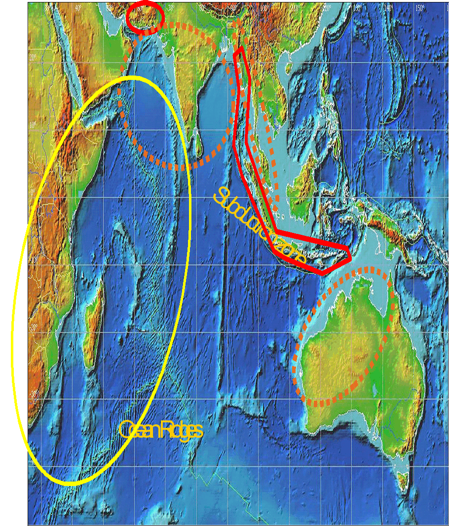
- The zones circled in red are subject to local tsunamis.
- The zones delineated by dotted orange lines are subject to regional tsunamis.
- The zones circled in yellow are subject to distant tsunamis.
Source: CEA/DASE
Indeed, as compared to other regions whose countries are threatened by local, regional and sometimes distant tsunamis, all the Indian Ocean countries - with the exception of Burma and India - are exposed to only one type of tsunami:
- Myanmar, the Andaman and Nicobar Islands, Timor, Iran and Pakistan can be touched by local tsunamis. Therefore, for the warning system to be effective, these countries must be equipped with dense monitoring systems and very rapid warning centres, with teams on-duty 24 hours a day, 7 days a week.
- Myanmar, Thailand, Malaysia, Singapore, Sri Lanka, India, Australia and Oman are threatened by regional tsunamis: they therefore have more time to react in the event of a warning being given.
- Finally, the 16 countries located within the yellow circle are exposed to teletsunamis: their monitoring systems can therefore be less dense and their warning centres need only be on-call.
As a result, the overall investment and operating costs are (in proportion to the size of the Indian Ocean) 3 to 5 times less than in the other basins, whose countries must be equipped to face all types of tsunami.
On the other hand, the relative isolation of the various warning systems could explain the difficulties encountered in trying to integrate the national systems into a regional warning system.
* 35 Information (rather than warning) messages are issued, because the data available to these two centres is not sufficient to allow them to issue reliable warning bulletins. These two centres currently base their analysis on the data transmitted by 30 seismic stations, 41 tide gauges and one DART buoy installed off the coast of Thailand.
* 36 As has already been pointed out, the terminology used often differs according to region. The terminology chosen for the Indian Ocean zone is meant to avoid offending national susceptibilities by maintaining a balance between the ICG member states.