


SENAT
Report n° 117 (2007-2008) by M. Roland COURTEAU, Senator (for the parliament office for the evaluation of scientific and technological choices) - Appendix to the minutes of the 7 December 2007 session
Disponible au format Acrobat (21 Moctets)
2. Significant advantages
France can rely on its experience in Polynesia and its leading geoscientific and oceanographic organizations to help it set up international tsunami warning systems.
a) The precedent in Polynesia
France has acquired precious experience in French Polynesia through the management of the Polynesian tsunami prevention centre. It managed to set up a national, operational and autonomous warning system that is capable of managing the entire warning chain, from detecting earthquakes to evacuating the concerned population. This system has slowly been perfected over the years to take into account inadequacies observed during past tsunamis, as well as scientific advances.
Therefore, this experience could be applied to the setting up of warning systems in the other basins. For example, the decision matrices 42 ( * ) and specialized emergency plans are two fundamental tools that could be borrowed and adopted to the specificities of each basin and member state.
b) Leading organizations in the geosciences and oceanography fields
Furthermore, France has excellent organizations that can actively improve the effectiveness of the tsunami warning systems, as long as they are provided with the necessary means to do so.
Rather than listing all of the research institutes and universities that France can depend on, your rapporteur will simply name five bodies which appear to him to be essential for setting up a tsunami warning system: CEA, IPGP, SHOM, IFREMER ("French Research Institute for Sea Exploration") and BGRM.
CEA, through its DASE ("Analysis, Surveillance and Environment Department"), already plays a central role in tsunami prevention in French Polynesia and is meant to eventually become the national tsunami warning centre within the framework of the Mediterranean/Northeast Atlantic, Indian Ocean and Caribbean warning systems.
In addition to managing the 6 seismic stations within the framework of the Comprehensive Nuclear-Test-Ban Treaty, CEA ensures nation-wide seismic monitoring and is responsible for informing the civil protection authorities as soon as an earthquake of magnitude 4 or greater has been detected on French territory. To carry out this mission, CEA has at its disposal a digital seismic network made up of 40 stations, whose data is transmitted in real time to the national data centre in Bruyères-le-Châtel. This network is monitored by an automatic monitoring system liable to broadcast technical warnings in the event of a software or transmission-system failure. CEA also has a team of engineers on-call 24 hours a day, 365 days a year, made up of a dozen seismologists, three computer engineers and some ten engineers responsible for monitoring and maintaining the networks. These personnel enjoy all the necessary means for network maintenance and data processing (laptop computers, digital communication links, vehicles, etc.).
CEA's offices also host the European-Mediterranean Seismological Centre (EMSC). This centre collects in real time the seismic bulletins issued by 59 different bodies and networks using data from 1,700 stations, which are then immediately archived and broadcast via its website. The centre makes available not only the list of earthquakes (with their location, depth and magnitude), but also maps allowing for their visualization. In addition, depending on the observed magnitude, the EMSC is responsible for issuing warning messages to the Council of Europe and the civil protection centres, according to a predefined list.
Furthermore, CEA is specialized in tsunami modelling and has carried out numerous studies for French Polynesia, including the elaboration of the region's tsunami exposure map and a historic study of French Polynesian tsunamis from 1837 to the present day.
Finally, CEA staff includes one of the few internationally renowned tsunami experts, who participated during several years in efforts to improve the tsunami warning system in the Pacific, in particular as chairman of the ICG/Pacific, and is currently serving as an expert advisor in the setting up of warning systems for the three other basins.
IPGP is also an essential interlocutor for setting up warning systems in the Caribbean and in the Indian Ocean, where it is responsible for monitoring two types of tsunami-generating phenomena: volcanoes and earthquakes. 43 ( * )
First of all, IPGP's observatories are responsible for monitoring the volcanic activity of Mount Soufrière in Guadeloupe, Mount Pelée in Martinique and Piton de la Fournaise in La Réunion.
In the West Indies, IPGP has a second mission which consists of continuously monitoring and recording the regional seismicity (for Martinique, Guadeloupe and the nearby islands) linked to the tectonic activity of the Lesser Antilles island arc. The objectives are 1) to alert the authorities of the characteristics of observed earthquakes and the possible after-shocks that could occur and 2) to establish over the long term the spatiotemporal characteristics of the regional and local seismicity, in order to contribute to the elaboration of seismic maps.
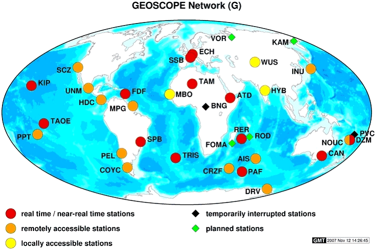
Furthermore, IPGP is responsible for the GEOSCOPE programme (i.e., the French component of the broadband seismic measurement networks). GEOSCOPE is made up of 28 operational stations 44 ( * ) , 13 of which transmit their data in real time 45 ( * ) (in particular, one in La Réunion, one in Martinique, one in Hawaii, one in Djibouti 46 ( * ) , one on Kerguelen Island, one in Algeria, one in Australia and one in the Marquesas Islands). The data collected by the seismic station in New Caledonia is transmitted in less than two hours. This network helps in the localization of earthquakes all over the world. Because of the quality of its stations and their geographical distribution, it is also closely involved in setting up the international tsunami warning systems, in particular those of the Indian Ocean and the West Indies.
IFREMER also plays a central role in setting up a tsunami warning system. This public body, created in 1984, plays a dual industrial-commercial role and contributes, through its work and expertise, to our understanding of the oceans and oceanic resources, the monitoring of marine and coastal environments, and the sustainable development of marine activities.
To these ends, it designs and implements observation, experimentation and monitoring tools and manages France's oceanographic fleet for the entire scientific community. As a result, it is closely connected to all projects concerned with the sea and requiring specific instrumentation, such as the ANTARES project (the installation of a thousand photodetectors, whose data is transmitted by cable), the installation of a seabed seismometer in partnership with Géo-Azur, and the various bathymetric projects.
Indeed, it is internationally renowned for its skills and experience. Therefore, it was put in charge of testing the tsunamimeters developed by the Germans for the Indonesian warning system.
Its expertise in geophysical risks, in combination with its exploration capacities make it an essential partner for setting up tsunami warning systems in the Mediterranean, Caribbean and Indian Ocean.
SHOM, converted into a public establishment last May, also has a fundamental role to play within the framework of its mission to support public maritime policies. Its network of tide gauges and its cartographic and bathymetric data are indispensable tools in setting up an effective tsunami warning system.
Finally, BRGM constitutes an important partner. A public industrial-commercial body placed under the authority of the Ministry of Higher Education and Research and the Ministry of the Environment and Sustainable Development, BRGM's activities with regard to natural risks concern the understanding and modelling of phenomena, the evaluation of the corresponding dangers, monitoring, studying the vulnerability of exposed sites, risk and prevention analysis, crisis preparedness, information diffusion, and training. Therefore, via its synthetic studies, BRGM provides national and local authorities with the necessary tools for natural risk prevention and the resulting territorial development.
* 42 These are pre-established criteria for issuing a warning. In Polynesia, 4 warning levels have been established, based on the magnitude of the earthquake, the distance of the source and the zones liable to be affected (distinguishing the Marquesas Islands from the rest of French Polynesia).
* 43 IPGP is also involved in the tsunami warning systems for the Pacific and Mediterranean zones, via the GEOSCOPE stations set up in these regions.
* 44 Among the 28 seismic stations, 18 are managed by IPGP, 6 are managed by the Ecole et Observatoire des Sciences de la Terre (EOST) in Strasbourg, 2 are managed by CEA/DASE, and 2 are co-managed with the United States Geological Survey (USGS). Station maintenance is also carried out in collaboration with several institutes [the EOST, the Institut de Recherche pour le Developement (IRD), CEA/DASE, the Comprehensive Test-Ban Treaty Organization (CTBTO), the Centre National d'Etudes Spatiales (CNES), the USGS, and local universities housing stations].
* 45 The data-transmission time is less than 1 minute.
* 46 The Djibouti station was made to function in real-time within the framework of the Comprehensive Nuclear-Test-Ban Treaty. However, its data is not transmitted directly to IPGP, but rather to the Vienna International Data Centre.