


SENAT
Report n° 117 (2007-2008) by M. Roland COURTEAU, Senator (for the parliament office for the evaluation of scientific and technological choices) - Appendix to the minutes of the 7 December 2007 session
Disponible au format Acrobat (21 Moctets)
b) The current situation
Today, the Intergovernmental Coordination Group for the Tsunami Early Warning and Mitigation System in the Pacific Ocean has 30 member states: Canada, Chile, Ecuador, El Salvador, the Fiji Islands, France, Guatemala, Indonesia, Japan, Malaysia, Mexico, New Zealand, Nicaragua, Papua New Guinea, Peru, the Philippines, South Korea, Russia, Samoa, Singapore, Thailand, Tonga, the United States and Vietnam.
The first Master Plan was published in 1989. The current version dates from 1999. It describes the situation of the warning system at that date, points out the inadequacies and proposes solutions. It also describes the warning-system strategy, which has four main parts:
- evaluating the hazard and risks (historical data, on-the-ground research, computer modelling);
- warning (warning centres, monitoring networks, data transmission);
- prevention (education, evacuation, environmental planning);
- research.
Concerning those aspects linked to the evaluation of this phenomenon and to research, the ICG/Pacific has closely cooperated since the 1990s with the Tsunami Commission of the International Union of Geodesy and Geophysics (IUGG), with which it has organized 6 international workshops centred around tsunamis. The ICG/Pacific has funded the creation of a database compiling an inventory of all tsunamis to have occurred in and outside the Pacific, as well as the creation of a computer program for modelling tsunamis that is available to all UNESCO member states.
Three international warning centres are currently in place: PTWC in Hawaii, the West Coast and Alaska Tsunami Warning Center (WC-ATWC) and the Northwest Pacific Tsunami Advisory Center (NWPTAC), managed by JMA. 10 ( * ) Each of these three centres is responsible for a separate zone, as shown in the map below.
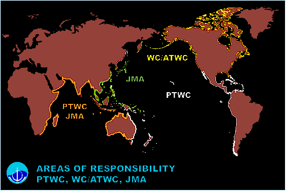 Source: ITIC
(1) The role of the Pacific Tsunami Warning Center (PTWC)
PTWC, which is administered and financed by the National Oceanic and Atmospheric Administration (NOAA) of the United States, serves as the operational centre for the Pacific tsunami warning system. PTWC has a current staff of twelve, which provides round-the-clock monitoring, seven days a week. It has direct, real-time access to more than 150 seismic stations spread out all over the world, which inform PTWC of all earthquakes with a magnitude of over 5.5. It also has access to data from nearly 100 tide gauges and 26 tsunamimeters installed in the Pacific, which verify if a tsunami has indeed been generated and estimate its amplitude.
The installation of tsunamimeters since 1997 has greatly improved the system's effectiveness by significantly reducing the number of false alerts. Indeed, up until then, evaluating the tsunami risk essentially depended on data from the seismic stations: once an earthquake with a magnitude of over 7.5 was detected, the alert was immediately given. While the tide gauges near the epicentre were still needed to verify whether a tsunami had indeed been generated, for these zones, the information arrived at the same time as the tsunami. It was therefore necessary to evacuate these areas as a precaution. However, not all earthquakes, even those of great magnitude, generate tsunamis. In addition, the number of potentially concerned countries depends on the formation and propagation of the tsunami, information which seismic data is currently unable to provide with sufficient precision. Therefore, tsunamimeters allow scientists to refine the analysis, follow the tsunami's propagation and issue (or cancel) a warning up until the very last minute.
PTWC, ATWC and NWPTAC currently issue three types of information bulletin. The content of these messages is regularly revised; indeed, a study is currently under way to revise the contents so as to make them more precise.
When an earthquake with a magnitude of between 6.5 and 7.5 occurs, an information message is sent to all civil authorities, specifying the hour and location of the earthquake and the fact that no tsunami has been generated.
|
Example of an information message PACIFIC TSUNAMI WARNING CENTER/NOAA/NWS TSUNAMI BULLETIN NUMBER 001 ISSUED AT 2117Z 16 OCT 2007 THIS BULLETIN APPLIES TO AREAS WITHIN AND BORDERING THE PACIFIC OCEAN AND ADJACENT SEAS...EXCEPT ALASKA...BRITISH COLUMBIA... WASHINGTON...OREGON AND CALIFORNIA. ... TSUNAMI INFORMATION BULLETIN ... THIS BULLETIN IS FOR INFORMATION ONLY. THIS BULLETIN IS ISSUED AS ADVICE TO GOVERNMENT AGENCIES. ONLY NATIONAL AND LOCAL GOVERNMENT AGENCIES HAVE THE AUTHORITY TO MAKE DECISIONS REGARDING THE OFFICIAL STATE OF ALERT IN THEIR AREA AND ANY ACTIONS TO BE TAKEN IN RESPONSE. AN EARTHQUAKE HAS OCCURRED WITH THESE PRELIMINARY PARAMETERS ORIGIN TIME - 2106Z 16 OCT 2007 COORDINATES - 25.5 SOUTH 179.6 EAST DEPTH - 411 KM LOCATION - SOUTH OF FIJI ISLANDS MAGNITUDE - 6.6 EVALUATION A DESTRUCTIVE TSUNAMI WAS NOT GENERATED BASED ON EARTHQUAKE AND HISTORICAL TSUNAMI DATA. THIS WILL BE THE ONLY BULLETIN ISSUED FOR THIS EVENT UNLESS ADDITIONAL INFORMATION BECOMES AVAILABLE. THE WEST COAST/ALASKA TSUNAMI WARNING CENTER WILL ISSUE PRODUCTS FOR ALASKA...BRITISH COLUMBIA...WASHINGTON...OREGON...CALIFORNIA. Source: PTWC |
PTWC's reaction time is very short (never more than 20 minutes): in the above example, the earthquake occurred at 9:06 p.m. and the information message was sent at 9:17 p.m.
If an earthquake with a magnitude of between 7.5 and 7.9 occurs, there is a risk of a regional tsunami being generated. Depending on the supposed direction taken by the tsunami - and, therefore, the risk run by the concerned countries - PTWC will issue a warning bulletin (for those countries considered the most at risk) and/or a watch bulletin (for those countries considered less at risk). The warning is canceled if the data provided by the tide gauges and/or tsunamimeters confirms the absence of a tsunami. Otherwise, supplementary bulletins will be issued with additional information.
|
Example of a warning/watch bulletin WEPA40 PHEB 081908 TSUPAC TSUNAMI BULLETIN NUMBER 001 PACIFIC TSUNAMI WARNING CENTER/NOAA/NWS ISSUED AT 1908Z 08 MAY 2007 THIS BULLETIN IS FOR AREAS WITHIN AND BORDERING THE PACIFIC OCEAN AND ADJACENT SEAS...EXCEPT ALASKA...BRITISH COLUMBIA... WASHINGTON...OREGON AND CALIFORNIA. ... A TSUNAMI WARNING AND WATCH ARE IN EFFECT ... A TSUNAMI WARNING IS IN EFFECT FOR JAPAN / RUSSIA / MARCUS IS. / N. MARIANAS A TSUNAMI WATCH IS IN EFFECT FOR GUAM / WAKE IS. / TAIWAN / YAP / PHILIPPINES / MARSHALL IS. / CHUUK / POHNPEI / BELAU / MIDWAY IS. / KOSRAE / INDONESIA / PAPUA NEW GUINEA / NAURU / KIRIBATI / JOHNSTON IS. / HAWAII FOR ALL OTHER AREAS COVERED BY THIS BULLETIN, IT IS FOR INFORMATION ONLY AT THIS TIME. THIS BULLETIN IS ISSUED AS ADVICE. ONLY NATIONAL OR LOCAL GOVERNMENT AGENCIES HAVE THE AUTHORITY TO MAKE DECISIONS REGARDING THE OFFICIAL STATUS IN EACH AREA AND ANY ACTIONS TO BE TAKEN IN RESPONSE. AN EARTHQUAKE HAS OCCURRED WITH THESE PRELIMINARY PARAMETERS ORIGIN TIME - 1848Z 08 MAY 2007 COORDINATES - 38.2 NORTH 143.1 EAST DEPTH - 47 KM LOCATION - OFF EAST COAST OF HONSHU JAPAN MAGNITUDE - 8.2 EVALUATION IT IS NOT KNOWN THAT A TSUNAMI WAS GENERATED. THIS WARNING IS BASED ONLY ON THE EARTHQUAKE EVALUATION. AN EARTHQUAKE OF THIS SIZE HAS THE POTENTIAL TO GENERATE A DESTRUCTIVE TSUNAMI THAT CAN STRIKE COASTLINES NEAR THE EPICENTER WITHIN MINUTES AND MORE DISTANT COASTLINES WITHIN HOURS. AUTHORITIES SHOULD TAKE APPROPRIATE ACTION IN RESPONSE TO THIS POSSIBILITY. THIS CENTER WILL MONITOR SEA LEVEL DATA FROM GAUGES NEAR THE EARTHQUAKE TO DETERMINE IF A TSUNAMI WAS GENERATED AND ESTIMATE THE SEVERITY OF THE THREAT. ESTIMATED INITIAL TSUNAMI WAVE ARRIVAL TIMES. ACTUAL ARRIVAL TIMES MAY DIFFER AND THE INITIAL WAVE MAY NOT BE THE LARGEST. THE TIME BETWEEN SUCCESSIVE TSUNAMI WAVES CAN BE FIVE MINUTES TO ONE HOUR. LOCATION COORDINATES ARRIVAL TIME -------------------------------- ------------ ------------ JAPAN HACHINOHE 40.5N 142.0E 1932Z 08 MAY KUSHIRO 42.5N 144.5E 1933Z 08 MAY KATSUURA 35.1N 140.3E 1934Z 08 MAY SHIMIZU 32.5N 133.0E 2047Z 08 MAY OKINAWA 26.2N 127.8E 2148Z 08 MAY RUSSIA URUP IS 46.1N 150.5E 2016Z 08 MAY PETROPAVLOVSK K 53.2N 159.6E 2123Z 08 MAY SEVERO KURILSK 50.8N 156.1E 2130Z 08 MAY UST KAMCHATSK 56.1N 162.6E 2148Z 08 MAY MEDNNY IS 54.7N 167.4E 2150Z 08 MAY MARCUS IS. MARCUS IS. 24.3N 154.0E 2055Z 08 MAY N. MARIANAS SAIPAN 15.3N 145.8E 2159Z 08 MAY GUAM GUAM 13.4N 144.7E 2216Z 08 MAY WAKE IS. WAKE IS. 19.3N 166.6E 2223Z 08 MAY TAIWAN HUALIEN 24.0N 122.0E 2234Z 08 MAY YAP YAP IS. 9.5N 138.1E 2252Z 08 MAY PHILIPPINES PALANAN 17.1N 122.6E 2253Z 08 MAY LEGASPI 13.5N 124.0E 2312Z 08 MAY DAVAO 6.5N 126.0E 2339Z 08 MAY MARSHALL IS. ENIWETOK 11.4N 162.3E 2256Z 08 MAY KWAJALEIN 8.7N 167.7E 2341Z 08 MAY MAJURO 7.1N 171.4E 0010Z 09 MAY CHUUK CHUUK IS. 7.4N 151.8E 2258Z 08 MAY POHNPEI POHNPEI IS. 7.0N 158.2E 2312Z 08 MAY BELAU MALAKAL 7.3N 134.5E 2316Z 08 MAY MIDWAY IS. MIDWAY IS. 28.2N 177.4W 2325Z 08 MAY KOSRAE KOSRAE IS. 5.5N 163.0E 2340Z 08 MAY INDONESIA GEME 4.6N 126.8E 2346Z 08 MAY BEREBERE 2.5N 129.0E 2356Z 08 MAY PATANI 0.4N 128.8E 0022Z 09 MAY WARSA 0.6S 135.8E 0022Z 09 MAY MANOKWARI 1.0S 134.5E 0032Z 09 MAY JAYAPURA 2.4S 140.8E 0042Z 09 MAY SORONG 0.8S 131.1E 0045Z 09 MAY PAPUA NEW GUINE KAVIENG 2.5S 150.7E 0025Z 09 MAY MANUS IS. 2.0S 147.5E 0029Z 09 MAY VANIMO 2.6S 141.3E 0040Z 09 MAY RABAUL 4.2S 152.3E 0044Z 09 MAY WEWAK 3.5S 144.0E 0053Z 09 MAY AMUN 6.0S 154.7E 0109Z 09 MAY KIETA 6.1S 155.6E 0112Z 09 MAY MADANG 5.2S 145.8E 0112Z 09 MAY LAE 6.8S 147.0E 0150Z 09 MAY PORT MORESBY 9.3S 146.9E 0308Z 09 MAY NAURU NAURU 0.5S 166.9E 0043Z 09 MAY KIRIBATI TARAWA IS. 1.5N 173.0E 0056Z 09 MAY KANTON IS. 2.8S 171.7W 0224Z 09 MAY CHRISTMAS IS. 2.0N 157.5W 0337Z 09 MAY MALDEN IS. 3.9S 154.9W 0412Z 09 MAY FLINT IS. 11.4S 151.8W 0506Z 09 MAY JOHNSTON IS. JOHNSTON IS. 16.7N 169.5W 0059Z 09 MAY HAWAII NAWILIWILI 22.0N 159.4W 0153Z 09 MAY HONOLULU 21.3N 157.9W 0207Z 09 MAY HILO 20.0N 155.0W 0228Z 09 MAY BULLETINS WILL BE ISSUED HOURLY OR SOONER IF CONDITIONS WARRANT. THE TSUNAMI WARNING AND WATCH WILL REMAIN IN EFFECT UNTIL FURTHER NOTICE. THE JAPAN METEOROLOGICAL AGENCY MAY ALSO ISSUE TSUNAMI MESSAGES FOR THIS EVENT TO COUNTRIES IN THE NORTHWEST PACIFIC AND SOUTH CHINA SEA REGION. IN CASE OF CONFLICTING INFORMATION... THE MORE CONSERVATIVE INFORMATION SHOULD BE USED FOR SAFETY. THE WEST COAST/ALASKA TSUNAMI WARNING CENTER WILL ISSUE BULLETINS FOR ALASKA - BRITISH COLUMBIA - WASHINGTON - OREGON - CALIFORNIA. Source: PTWC |
An earthquake with a magnitude of over 7.9 risks provoking a tsunami that will cross the entire Pacific. For the Pacific zone, PTWC sends its bulletins to more than 100 different sites.
At this stage, it became clear that the system could only be effective if it benefited from excellent international cooperation. While it is true that the United States has its own seismic stations and tide gauge stations, as well as accounting for most of the tsunamimeters, the system also collects data from the measuring devices of other countries. Therefore, the rapid, free exchange of all of the data is essential. PTWC must therefore work in close collaboration with other international, national and regional warning centres, which make their data available to PTWC. In particular, the WC-ATWC 11 ( * ) is meant to be able to stand in for PTWC in the case of technical difficulties.
Furthermore, improving the system is dependent on the installations of each subzone, meaning a sufficient number of tide gauges and tsunamimeters.
For instance, the following map illustrates the work remaining to be done in the South Pacific, which appears underequipped, both off the coast of Chile and around the Tonga Archipelago.
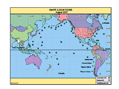
Source: International Tsunami Information Centre
* 10 The WC-ATWC and NWPTAC will be considered in detail in the following sections on the American model and the Japanese model, respectively.
* 11 West Coast/Alaska Tsunami Warning Center.