


SENAT
Report n° 117 (2007-2008) by M. Roland COURTEAU, Senator (for the parliament office for the evaluation of scientific and technological choices) - Appendix to the minutes of the 7 December 2007 session
Disponible au format Acrobat (21 Moctets)
b) The Japanese model
(1) A system especially well-suited to local tsunamis
With an average of 2,000 earthquakes per year (almost 5 per day) liable to be felt by the population, Japan is the most earthquake-prone country in the world. Many of these earthquakes occur at sea, which explains why Japan is also the most tsunami-prone country in the world. The following table lists the most destructive tsunamis since the beginning of the 20 th century.
List of Japanese tsunamis
since the beginning of the 20 th century
|
Year |
Epicentre location |
Depth (km) |
Magnitude |
Maximum amplitude of the tsunami, as measured by a tide gauge |
Damages (according to the Japanese rating system) (*) |
|
1933 |
Off Sanriku |
0 |
8.1 |
143 |
6 |
|
1944 |
Off Kii peninsula |
40 |
7.9 |
115 |
5 |
|
1946 |
Off Kii peninsula |
24 |
8.0 |
280 |
5 |
|
1952 |
Off Kushiro (Hokkaido) |
54 |
8.2 |
100 |
1 |
|
1960 |
Near coast of northern Pen |
0 |
8.5/9.5 |
305 |
4 |
|
1964 |
Off Nigata pref. |
34 |
7.5 |
140 |
2 |
|
1968 |
Off east of Kyushu |
30 |
7.5 |
116 |
2 |
|
Off Sanriku |
0 |
7.9 |
295 |
2 |
|
|
1969 |
Off east of Hokkaido |
30 |
7.8 |
130 |
2 |
|
1973 |
Off SE of Nemuro (Hokkai) |
40 |
7.4 |
>280 |
2 |
|
1983 |
Off Akita pref. |
14 |
7.7 |
194 |
4 |
|
1993 |
Off SW Hokkaido |
35 |
7.8 |
>175 |
5 |
|
1994 |
Off east of Hokkaido |
28 |
8.2 |
168 |
2 |
|
1996 |
Near Irian Jaya (Indonesia) |
33 |
8.1 |
104 |
1 |
|
2003 |
Off Kushiro (Hokkaido) |
45 |
8.0 |
255 |
3 |
|
2004 |
Off Kii peninsula |
38 |
7.1 |
66 |
1 |
|
Off Kii peninsula |
44 |
7.4 |
101 |
|
(*) |
Rating system for damages (for Japan) |
|
1. |
Minor damages observed on boats and farms. |
|
2. |
Minor damages observed on houses and roads. |
|
3. |
Victims/destroyed houses (less than for class 4). |
|
4. |
Victims (less than 20) or destroyed houses (less than 1,000). |
|
5. |
More than 200 victims or more than 10,000 destroyed houses. |
|
6. |
More than 2,000 victims or more than 100,000 destroyed houses. |
|
7. |
More than 20,000 victims or more than 1,000,000 destroyed houses. |
Source: Japan Meteorological Agency
In addition, while Japan is concerned by transpacific teletsunamis, it is above all affected by local tsunamis that are often devastating. Therefore, this country has set up a warning system capable of alerting the population in only a few minutes.
The Japan Meteorological Agency (JMA), under the authority of the Ministry of Infrastructure and Transportation, constitutes the country's nation-wide, multi-risk warning centre. JMA collects data on natural phenomena and issues warnings to the authorities and the public should the need arise.
Insofar as local tsunamis leave little time to act, the Japanese warning system favours rapidly emitting a warning message, even if it should later turn out to be false. Within three minutes following the detection of a tsunami, JMA will issue a message with the estimated time of the tsunami's arrival, the concerned coasts and the estimated height of the wave(s).
There are two types of local tsunami forecast messages: warning messages (the wave must be higher than 1 metre) and information messages (when the wave is between 50 cm and 1 metre in height).
In addition, there exist two categories of warning messages: messages for tsunamis with estimated waves of up to two metres and messages for major tsunamis with waves of three metres or higher.
Tsunami forecast and information
|
Tsunami forecast |
Created within 3 to 5 minutes following the earthquake. Distributed according to the height of the tsunami.
|
|||||||||||
|
Information on the estimated time of arrival and the height of the tsunami for each coastal region. |
||||||||||||
|
Information on the time of arrival of the high tide and the tsunami on the coasts. |
||||||||||||
|
Information on the actual time of arrival and height of the tsunami. |
||||||||||||
Source: Japan Meteorological Agency
In addition, JMA has divided the Japanese coast into 66 regions, which receive warning messages and information when they are concerned by a tsunami risk.
Division of the Japanese coast into 66 regions
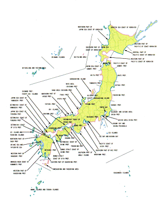
Source: Japan Meteorological Agency
JMA benefits from a very dense network of seismic stations (182) and tide gauges (80), whose data is supplemented by that provided by the measuring devices of the local governments, the NIED 17 ( * ) and the coast guard. This information is transmitted via satellite in real time to JMA, where it is processed by computer in order to determine as quickly as possible the earthquake's hypocentre and magnitude and if a tsunami has indeed been generated.
However, the extremely short amount of time (3 minutes) allowed JMA to issue a warning message does not, in fact, allow it to verify if the detected earthquake has actually provoked a tsunami (the network of stations for measuring sea level is not sufficiently dense to detect a tsunami in under 3 minutes). In reality, JMA relies on tsunami simulations based on 100,000 tsunami-generating earthquakes, comparing the detected earthquake to the simulation of the earthquake with the most similar characteristics. At the same time, once the information on the detected earthquake has been collected, a new simulation is carried out to refine the information given on the potential tsunami.
The warning messages are very widely distributed.
Firstly, they are sent to local authorities and disaster-control bodies.
Secondly, JMA has passed a cooperative agreement with the public television network NHK for the broadcasting of warning messages. NHK manages 10 TV channels and 3 radio stations, which all issue warnings in the event of a tsunami. When an alert is given, the TV and radio programmes are interrupted and a message is broadcast, accompanied with a map of Japan with the at-risk zones coloured yellow, orange or red, depending on the amplitude of the forecast tsunami.
During the Kobe earthquake of 17 January 1995, serious systemic failures were observed, due, in particular, to an insufficient distribution of earthquake information. For this reason, the tsunami warning system now favours diverse channels for the transmission of information to persons capable of making decisions. For example, in the Wakayama Prefecture, at least three bodies now receive JMA messages and are liable to activate the sirens to alert the public to the danger.
* 17 National Research Institute for Earth Science and Disaster Prevention.