


SENAT
Report n° 117 (2007-2008) by M. Roland COURTEAU, Senator (for the parliament office for the evaluation of scientific and technological choices) - Appendix to the minutes of the 7 December 2007 session
Disponible au format Acrobat (21 Moctets)
(2) A well-prepared population
Local tsunamis necessitate very short reaction times. In at-risk zones, the local authorities have set up evacuation plans detailing the routes to take, the buildings that can serve as a refuge and the zones to reach in order to be safe. Particular attention has been paid to signalling and several types of signs have been created:
- signs indicating the direction and distance to the safety zones;
- warning signs for those zones prone to inundation in the event of a tsunami;
- signs indicating safety zones (out of reach of the tsunami) and "refuge" buildings.
These signs rely almost entirely on drawings, allowing them to be understood by everyone.
Sirens have also been installed along the coasts, with a range of 1 to 2 kilometres, in order to warn persons on the beaches and along the seashore.
In addition, numerous measures have been taken to inform and raise the awareness of the public. For example, the department responsible for dealing with catastrophes and fires, placed under the authority of the Ministry of Internal Affairs and Communications, has developed an informative CD for shoreline residents. This CD explains how tsunamis are generated and spread, and then describes what to do should the sirens be sounded and/or a strong earthquake be felt.
The inhabitants of certain districts are involved in the process of designing the evacuation plans. The objective is to inform the public of the damages caused by past tsunamis, convince it of the usefulness of such plans, and profit from their knowledge of the area in order to choose the best evacuation routes.
Training exercises are also carried out, to test the chosen escape routes and solve any observed failures or shortcomings. Your rapporteur learned of a group of residents that worked during two years to construct an escape route (using railway tracks) providing rapid access to a zone located 10 metres above sea level.
For all that, Japan must still deal with public apathy in the face of such a rare phenomenon. Several persons pointed out to your rapporteur the worrying fact that during the last warnings of November 2006 and 13 January 2007, most residents remained at home, despite orders to evacuate. One possible explanation, other than a changing Japanese society, resides in the fact that the issuance of numerous false warnings has damaged the system's credibility.
(3) Considerable means dedicated to constructing protective structures and improving the warning system
Japan is the only country building more and more structures to protect against tsunamis. 18 ( * ) The municipality of Tokyo, which is responsible for the security of the islands off its coast, has sought to reduce the vulnerability of certain coasts by installing tetrapods and artificial reefs.
According to the information gathered by your rapporteur, more than 15,000 km of dikes have been built along the Japanese coast.
For those areas without a nearby building offering refuge and whose relief does not allow residents to rapidly access a zone several metres above sea level, the Japanese have constructed steel platforms with stairways. These platforms are earthquake-resistant and capable of resisting tsunami waves. They can shelter between 70 and 100 persons and are sometimes equipped with a siren.
Likewise, concrete walls or dikes are sometimes built in harbours threatened by tsunamis. These walls, whose height can be adjusted according to the estimated amplitude of the tsunami, are meant to "break" the waves and limit inundation.
In addition, Japan continues to invest heavily in the improvement of its warning system. JAMSTEC 19 ( * ) has launched a programme entitled DONET 20 ( * ) , whose objective is to equip the Tonankai zone with a network of 20 seismometers linked by cable that also act as pressure sensors, in order to more rapidly detect earthquakes and tsunamis originating in this zone. It should be pointed out that the study of past earthquakes has shown that the zone between the Bay of Suroga and the island of Shikoku produces an earthquake with a magnitude of 8 or greater every 100 to 150 years, at three different locations: in the regions of Tokai, Tonankai and Nankai.
The strong earthquakes liable to touch
the regions of Tokai, Tonankai and Nankai
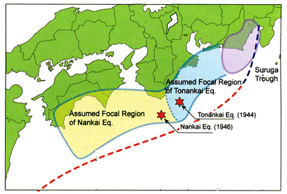
Source: Japan Meteorological Agency
In addition, in this same zone, two strong earthquakes have already occurred more or less instantaneously or were separated by only one or two days. Such an event would produce enormous damage. That is why this zone is under high monitoring.
Finally, Japan is greatly involved in the overall improvement of the world's tsunami warning systems, thanks to its very active policy of cooperation, in particular with the other Asian and Pacific countries.
Since 1960, the IISEE 21 ( * ) has organized a one-year training course for a dozen engineers from developing countries on seismology and earthquake prevention and mitigation techniques. Up until 1972, Japan and UNESCO codirected this training programme. However, in 1973, Japan's JICA 22 ( * ) became the sole director of the programme and in 2005 transformed it into a Masters in natural disaster prevention. In 2006, a tsunami module was introduced; when your rapporteur visited Japan in January 2007, this module was being followed by 5 students, or half of the programme's participants.
In addition, NIED and JICA have begun to set up a seismic network in Indonesia (the JISNET project): 23 broadband seismic stations have already been installed.
In the southwest Pacific, JICA has financed a programme to upgrade the seismic networks of the Fiji and Tonga islands: the South Pacific broadband seismic NETwork (SPANET). 6 broadband seismic stations have already been installed.
* 18 Most are multi-risk structures, because Japan must also confront cyclonal swells and typhoons.
* 19 Japan Agency for Marine-Earth Science and Technology, which corresponds to France's IFREMER.
* 20 Dense Oceanfloor Network System for Earthquakes and Tsunamis.
* 21 International Institute of Seismology and Earthquake Engineering.
* 22 Japon International Cooperation Agency.