


SENAT
Report n° 117 (2007-2008) by M. Roland COURTEAU, Senator (for the parliament office for the evaluation of scientific and technological choices) - Appendix to the minutes of the 7 December 2007 session
Disponible au format Acrobat (21 Moctets)
(2) A study on the vulnerability of the French coasts
BRGM also carried out on behalf of the Pollution and Risk Prevention Department a preliminary study on tsunamis in the Mediterranean and West Indies (Martinique and Guadeloupe) centred around three main themes:
- Identify the a priori most dangerous tsunami-generating zones for France's Mediterranean and West Indian coasts.
- Simulate extreme but possible events that could generate tsunamis.
- Identify France's most tsunami-vulnerable coasts.
Two tsunami-source types were chosen: earthquakes and landslides.
For the western Mediterranean , 59 seismic zones were identified for their supposedly homogeneous tectonic deformation and seismic potential. Next, a maximum earthquake 50 ( * ) was chosen as a reference for each zone. Likewise, IFREMER was charged with identifying underwater landslide zones on the continental shelf and slope off the French Mediterranean coasts; 20 zones were eventually identified and characterized by their maximum unstable volumes.
Based on seismic zonings and ground movements, 6 scenarios where chosen as a priori having the greatest tsunami-generating potential and/or representing the most likely sources of earthquakes or ground movements. They include:
- 3 earthquake scenarios
· A 6.8 magnitude earthquake with and an epicentre situated some fifty kilometres off the coast of the French Riviera in the Liguria Sea.
· A 6.7 magnitude earthquake centred in the Gulf of Lion, some one hundred kilometres from Perpignan.
· A 7.8 magnitude earthquake situated 25 km north of the Algerian coast.
- 3 underwater ground-movement scenarios
· A landslide located some twenty kilometres off the northwestern coast of Corsica; the destabilized volume is estimated at 0.75 km 3 .
· A landslide located some fifty kilometres off the coast of Perpignan, in the area of the Lacaze-Hérault underwater canyon, characterized by an unstable volume of 0.055 km 3 .
· A landslide estimated at nearly twenty-five kilometres southeast of Nice, with an unstable volume of 1 km 3 .
Simulations of these 6 scenarios indicate:
|
Scenario |
Magnitude or volume |
Maximum onshore wave height |
Time of arrival |
French coast affected (amplitude >0.5 m) |
|
North Liguria Sea earthquake |
M = 6.8 |
2 m in Antibes |
10 to 15 mins. |
St. Tropez to Nice |
|
Continental-terrace earthquake north of Algeria |
M = 7.8 |
4 m in St. Tropez, Cannes 3 m in La Ciotat, Nice, Villefranche |
95 to 100 mins. |
Marseille to Menton |
|
Gulf of Lion earthquake |
M = 6.7 |
0.6 m in Agde, Port-la-Nouvelle |
60 to 80 mins. |
Between Perpignan and Béziers |
|
Continental-terrace landslide west of Corsica |
V = 0.75 km 3 |
5-6 m north of Porto |
5 to 15 mins. |
Southwestern half of the coast between Porto and Bastia |
|
Lacaze-Hérault Canyon landslide |
V = 0.055 km 3 |
1.5 m in Perpignan 1 m in Frontignan and Beauduc (Capelude) |
45 to 80 mins. |
Perpignan to Beauduc |
|
Nice-Vintimille continental-terrace landslide |
V = 1 km 3 |
4 m in Antibes 3 m in Nice |
10 to 20 mins. |
St. Tropez to Menton (all the way to San Remo in Italie) |
The synthesis of these 6 scenarios results in a sectioning of the French Mediterranean coast according to the estimated level of vulnerability. This sectioning takes into account the maximum estimated sea level near the coast and the a priori possible run-up level, irrespective of the initial source of origin (earthquake or landslide). This represents an initial evaluation of the French coasts' exposure to tsunamis.
Considering the characteristics of the 6 catastrophic scenarios chosen as benchmarks, as well as the results of additional simulations that have been carried out, this synthetic map probably indicates rather well the regional level of tsunami exposure for this part of the French coast.
This preliminary regional evaluation relies on calculations with a cartographic precision of up to around 1:100,000 (calculations based on grids with a spatial resolution of 83 m x 83 m).
Therefore, it cannot be used for tsunami-risk planning at the local level (for example, in the elaboration of risk-prevention plans). Indeed, more precise studies remain essential for a detailed tsunami mapping at the local level according to the height, depth and duration of inundation, as well as the number of waves and the speed of the currents.
Tsunami-exposure map for the coasts of the Languedoc-Roussillon and Provence-Alpes-Côte d'Azur regions
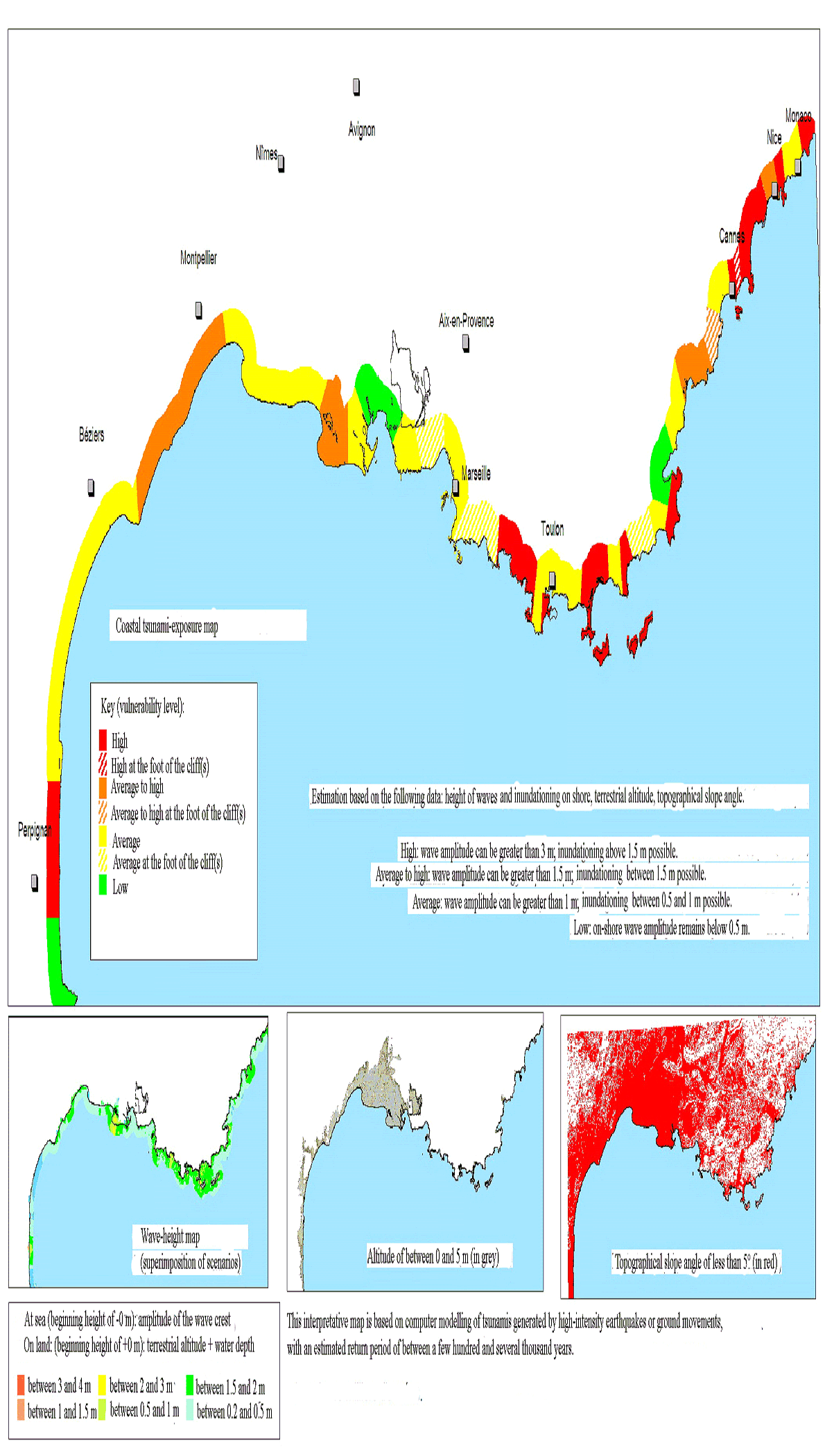
Source: BRGM
Tsunami-exposure map for the coasts of Corsica
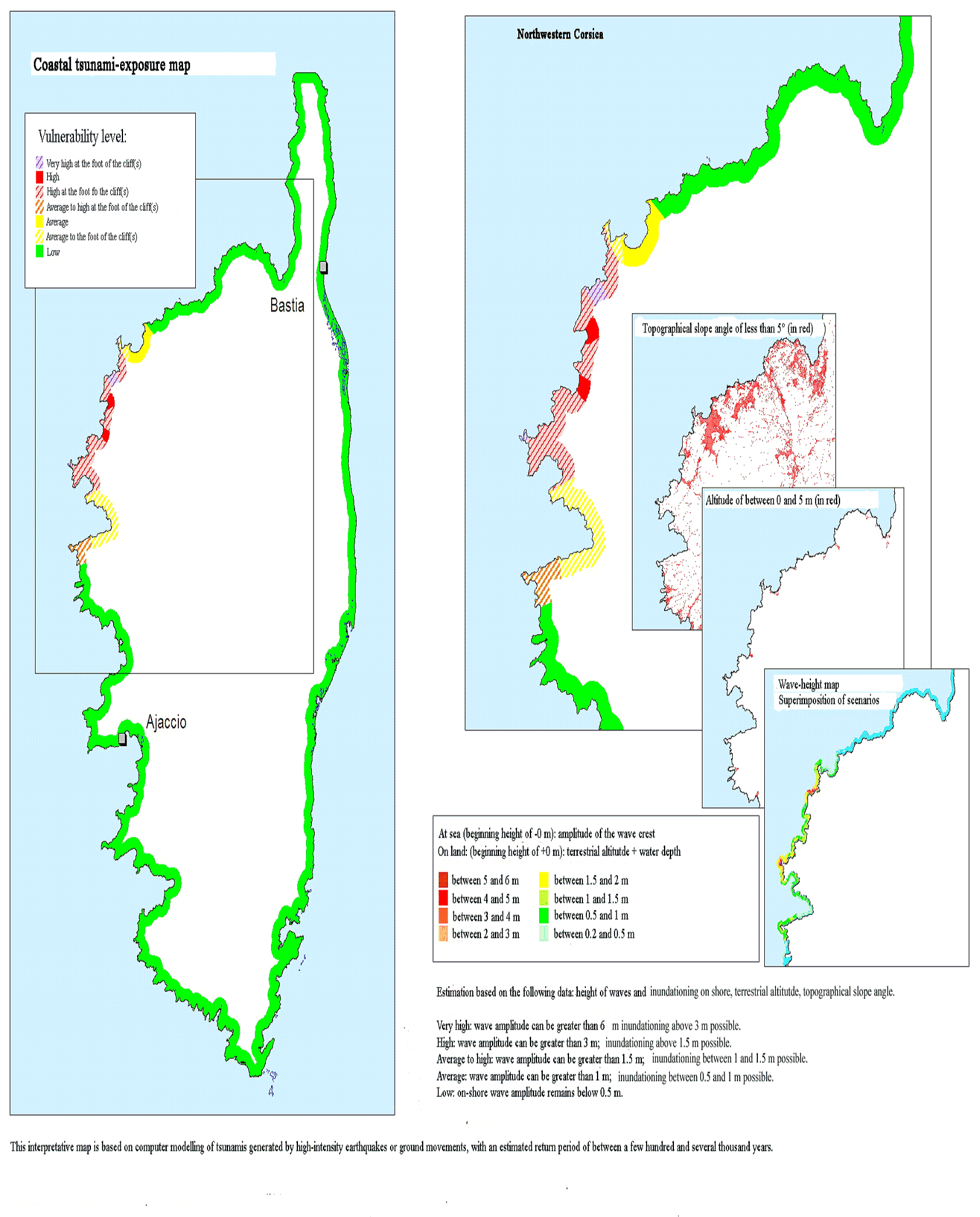
Source: BRGM
As regards the French West Indies , seismic zoning carried out in the area of the Caribbean Plate identified 32 seismic zones characterized by a maximum earthquake. Five seismic-source scenarios were chosen. Furthermore, based on an analysis of our current understanding of tsunami-generating landslides and volcanic eruptions/collapses, 3 additional scenarios were chosen.
Therefore, a total of 8 catastrophic scenarios were chosen as references and modelled:
The 5 seismic scenarios were the following:
· A magnitude 7.5 earthquake centred around the system of normal faults of the Marie-Galante graben.
· A magnitude 8.3 earthquake located in the Barbuda prism; in other words, in the subduction zone of the North American Plate sinking beneath the Caribbean Plate.
· A magnitude 7.5earthquake generated by the normal fault along the Anegada graben.
· A magnitude 7.6 earthquake generated by the left reverse fault of the Saint Lucia ridge.
· A magnitude 7.1 earthquake centred in the Barbados accretionary prism, generated by the reverse parallel faults along the subduction zone of the South American Plate sinking beneath the Caribbean Plate.
3 volcanic, subaerial ground-movement scenarios were also chosen:
· The 2003 Soufrière-Hills (Montserrat) event, corresponding to the collapse of the volcanic dome. The volume of debris entering the sea is estimated at 16 million m 3 .
· The 1902 Mount Pelée (Martinique) event, associated with the penetration into the sea of a lahar with a volume of around 5 million m 3 .
· The Soufrière (Guadeloupe) paleo-event concerning the collapse of a slope of the Soufrière volcano around 3100 B.C., sending an estimated 70 million m 3 of debris into the sea.
The following table presents the results of the 8 simulations:
|
Scenario |
Magnitude or volume |
Maximum onshore wave height |
Time of arrival |
French coast affected (amplitude >0.5 m) |
|
Marie-Galante graben earthquake |
M = 7.5 |
>3,5 m in Sainte-Marie (Martinique) |
10 to 15 mins. |
Northeastern Martinique Southern La Désirade Southern Grande-Terre (Guadeloupe) |
|
~ 5 m in La Désirade |
13 to 15 mins. |
|||
|
~ 3 m in Sainte-Anne (Guadeloupe) |
#177;15 mins. |
|||
|
Barbuda earthquake |
M = 8.3 |
=8 m in Le Moule, Anse-Bertrand, Clugny (Guadeloupe) |
20 to 40 mins. |
The entire coast of Grande-Terre and the northern coast of Basse-Terre (Guadeloupe) Western La Désirade Northeastern coasts of Martinique |
|
6 m in Le Marigot (Martinique) 4 m in La Trinité (Martinique) |
35 to 45 mins. |
|||
|
Anegada Passage earthquake |
M = 7.5 |
>1 m in Deshaies (Guadeloupe) |
60 mins. |
Northwestern Basse-Terre (Guadeloupe) |
|
Saint Lucia ridge earthquake |
M = 7.6 |
~1 m in Grande-Terre, southeastern Basse Terre, and Marie-Galante |
20 to 30 mins. |
Southern and eastern coasts of Grande-Terre, southeastern Basse Terre, Marie-Galante |
|
>2 m in la Désirade |
20 mins. |
Southern coast of La Désirade |
||
|
>3 m in Le Marigot and La Trinité (Martinique) |
15 to 30 mins. |
Eastern coast of Martinique |
||
|
Barbados prism earthquake |
M = 7.1 |
<0.5 in Le François |
15 to 20 mins. |
Southern coast of Martinique |
|
2003 Soufrière-Hills event (Montserrat) |
Landslide, V = 0.016 km 3 |
>0.5 m in Deshaies and Malendure |
12 to 15 mins. |
Northern and western coasts of Basse-Terre (Guadeloupe) |
|
1902 Mount Pelée event (Martinique) |
Lahars, V = 0.005 km 3 |
>3 m in Saint-Pierre |
<2 mins. |
Northwestern coast of Martinique |
|
La Soufrière event (Guadeloupe) |
Landslide, V = 0.07 km 3 |
>3 m in Trois Rivières and Basse-Terre |
<5 mins. |
Southern and western coasts of Basse-Terre, Les Saintes, western coast of Marie-Galante |
In the light of observations already made concerning the tsunami-exposure maps for the Mediterranean, these results demonstrate a high to very high level of tsunami vulnerability for almost all of Grande-Terre (Guadeloupe), eastern Basse-Terre (Guadeloupe), La Désirade, Les Saintes, Marie-Galante (except for the southern coast) and the eastern coast of Martinique.
Tsunami-exposure map for the coasts of Martinique
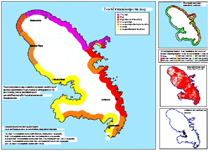
Source: BRGM
Tsunami-exposure map for the Guadeloupe archipelago
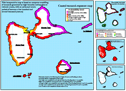
Source: BRGM
* 50 An earthquake with a known maximum historical magnitude, to which 0.5 degrees of magnitude is added to compensate for any uncertainties regarding the seismic data.