


SENAT
Report n° 230 (2006-2007) by M. Christian GAUDIN, Senator (for the parliament office for the evaluation of scientific and technological choices)
Disponible au format Acrobat (12 Moctets)
INTRODUCTION
"What's to explain the polar regions' strange attraction, at once so powerful and tenacious that, once returned home, one forgets the moral and physical fatigue and can't wait to return to them? What's to explain the incredible charm of these regions which are yet deserted and terrifying?"
Jean-Baptiste Charcot
Ladies and gentlemen,
"A century ago, exploring the polar regions was a heroic adventure, undertaken by poorly equipped men left to their own devices during solo expeditions. Little by little, scientists gave meaning to the support of fundamental research in these uninhabited zones, discovering - thanks to the development of international cooperation - the links that exist between the poles and our entire planet, as well as between the poles and the rest of the universe."
With these words, Bertrand Imbert and Claude Lorius, two great men of French polar research, bring to a close their presentation of the polar adventure in their book Le grand défi des pôles 1 ( * )1 . In this manner, they emphasize the deeply mysterious and spellbinding character of these regions to which, according to Commander Charcot, once discovered and despite their hostility, one can't wait to return. The poles, therefore, represent first and foremost adventure and a personal challenge. At the poles, one finds and leaves behind something of oneself.
Above all, they underline how the polar regions have gradually become an exceptionally rich research site; indeed, ever since 1959 the Antarctic continent has been reserved for peace and science - the only region of its kind in the world. While geography was the very first "polar science", all the other scientific domains were soon invited to locate the magnetic poles, describe new plant and animal species, and even observe the heavens. The very first International Polar Year was launched to study Venus and its movements, thereby marking the start of an exemplary collaboration.
Today, the poles are once again sites of scientific adventure. They are emerging as outposts, testifying to the changes affecting our planet, such as global warming and the threat to biodiversity. The poles may provide answers to such fundamental cosmological questions as the origins of the universe, or such futurology questions as exploring the solar system. Like the African Rift Valley, the poles provide valuable clues to man's ancient history. 1.5 million years of climatic archives are available in the Antarctic ice. But there is also much older ice which, separated from its "timeline", has not yet provided scientists with subjects of investigation.
The polar environment therefore offers a particularly wide range of research areas: this was but the first surprise for those who expected to find only ice, penguins and polar bears.
*
* *
Your rapporteur felt this very same surprise and wonderment some four years ago, when he was charged by the Senate Commission on Economic Affairs with reporting on the transposition bill for the 1991 Madrid Protocol.
Your rapporteur had the immense privilege of being introduced to the polar regions via an on-site visit to the French and Italian scientific research centres in Antarctica (Mario Zuchelli, Concordia and Dumont d'Urville). Thanks to this mission, he was able to visit the research installations, take the appropriate means of transportation (C-130 and Twin Otter planes, a 1,200-km trek by snowmobile and the Astrolabe ship) and meet with the researchers. Your rapporteur remains greatly impressed by the necessary engineering for undertaking research in an extreme environment. Nothing is possible without effective logistics. He also remains greatly impressed by the personal confrontation with the glacial desert, this hostile, lifeless environment, by his meeting with Concordia's winter residents, completely separated from the outside world and without the possibility of assistance for almost 9 months, and by the comradeship of the supply-trekkers, as well as by the infinite relief upon regaining Australia of finally seeing a tree, some grass...
*
* *
This discovery then turned into a study when, on the instigation of the Senate Commission on Economic Affairs, the Office decided to launch an evaluation of France's role in the issues surrounding polar research on the eve of the International Polar Year.
For the Office, it was also a question of pursuing the same path as laid down in the report presented in December 1989 by Jean-Yves Le Déaut, Deputy. This report greatly contributed to the definition of France's position when President François Mitterrand decided, at Commander Jacques-Yves Cousteau's instigation, that our country would oppose the enforcement of the Wellington Convention on mining in Antarctica and proposed negotiating a new agreement that resulted two years later in the Madrid Protocol, making Antarctica a nature reserve dedicated to science and peace.
*
* *
In preparing this report, your rapporteur met with those in charge of French polar research, as well as the concerned authorities. He visited the research teams and their laboratories. What's more, your rapporteur began a direct dialogue with our main partners in the polar regions, both from within Europe (Germany, Italy and the United Kingdom) and from without (the United States, Russia and, during my trip to Antarctica, New Zealand and Australia).
When travelling abroad as a member of the French Parliament, your rapporteur was very happy to observe the extent to which our polar operators and researchers were appreciated for their skills and work. Regardless of the circumstances, during a scientific presentation or visit, French researchers and technicians were often cited as references in their respective fields or as essential partners for a successful collaboration or research.
These meetings would not have been possible without the effective, competent and often passionate support of the French ambassadors and of their embassies' science departments. Thanks is also due to the foreign polar operators who were ever generous with their time and attention when welcoming this member of the French Parliament.
*
* *
After first reviewing the main characteristics as well as the legal status of the polar environments and considering the question of Antarctic tourism, your rapporteur will present the issues surrounding the various polar research fields. He will then consider the organization of the French presence in the polar regions, the organization of research, and the development of partnerships at both the European and international levels.
I. THE POLAR REGIONS: AN URGENT NEED FOR PROTECTION
It seemed appropriate to your rapporteur to begin this report with a presentation of the polar regions, for they are often little known, as well as of the very specific legal system that applies to Antarctica and to finish this presentation with the various issues surrounding the development of tourism.
A. EXTREME BUT FRAGILE REGIONS
The polar regions are both harsh, because extreme, and fragile, due to greater climate changes at the poles and sensitive flora and fauna. Nevertheless, the two regions are very different: an ocean surrounded by land in the north and a continent surrounded by the sea in the south.
They share a common question: where do the high latitudes start? While not wanting here to enter into a particularly complex scientific debate, becoming aware of the relative limits that vary according to the chosen criteria in fact represents a first step towards understanding the regions' specificity and fragility 2 ( * ) .
The first and most often agreed upon criterion is that of latitude, the limit marked by the two polar circles: 66°33. At this latitude, the sun does not rise at winter solstice and does not set - but rather brushes the horizon - at summer solstice. It also marks the height of the sun at noon between 0° and 46°54.
But this limit is too rigid because too narrow in the north and south. In the north, because it excludes for example a part of the Greenlandic and Siberian icecap. In the south, because it doesn't take into account the maximum extension of the ice shelf in September, which can extend beyond the polar circle; what's more, it is not the legal limit set by the Antarctic Treaty, which instead sets the limit at 60° south.
The next possible criteria are temperature-based limits , on both land and sea.
On the oceans, it is possible to set the limit at the maximum extension of the sea ice which, in the south, extends beyond the polar circle in the eastern Antarctic, while not reaching the polar circle in the western Antarctic. It is also possible to set the limit at an isotherm of 0°C in air temperature . In the south, it can be seen that this criterion would set the limit beyond the farthest extension of the icecap. However, in the north in the summer, this criterion would only cover the central portion of Greenland and the area above 80° latitude.
In the south, it is also possible to set the limit at the Antarctic convergence, which separates the cold southern waters from the warmer northern waters. This current, which completely surrounds the Antarctic, is undoubtedly the true physical and biological boundary. Nevertheless, its exact location varies considerably from year to year.
On the continents - and, therefore, essentially in the Arctic regions - it is also pertinent to set temperature-based limits. An isotherm of 0°C for the warmest month allows us to include these regions' vast ice-covered areas. Average air temperature is also a good criterion to shed light on those areas with frozen soil or permafrost. Permanent, continuous permafrost corresponds to an average annual temperature of -7 to -8°C, discontinuous permafrost to -4 to -1°C and sporadic permafrost to -1 to 0°C.
This criterion, marked principally by harsh winters, doesn't take into account very well the vigor of the summers and therefore the type of vegetation. That is why it is possible to propose as a criterion a bioclimatic cleavage: the tree limit . Indeed, while trees can withstand very cold temperatures, they require sufficiently warm summers to develop. Therefore, the tree limit depends upon the number of ice-free days, the possible duration of the vegetative period, as well as the average temperature of the warmest month . The isotherm of 10°C , or the "Köppen Line", seems to be one of the best markers. This line is very inclusive because in the northern hemisphere it lies very far south, as far as 51°, due to the continental climate of Canada and Siberia; however, it doesn't reach 60° in those areas more influenced by the ocean. Similarly, in the south, the line can be found as far north as 50°.
It is therefore particularly difficult to define the polar and subpolar regions, whose size varies depending on the season. The criteria used show that in the north the heart of these regions is rather limited in size and, what's more, that they may be influenced by fluctuations of only a few degrees that can significantly alter their climatic dynamics.
1. The Arctic Ocean
The North Pole is an oceanic zone of 12 to 14 million km², a "Northern Mediterranean", almost completely surrounded by land .
Its central area is covered by a permanent, multiyear ice shelf which in the winter can cover almost its entire surface and extend into the Pacific via the Bering Strait and into the Atlantic along the coast of Greenland. There are only three openings significant in size. The Bering Strait is the Arctic Ocean's opening to the Pacific.
80 km wide, it is only 38 m deep. The second opening is the Canadian archipelago, or the "Northwest Passage"; it does not allow for significant ocean traffic. The only real opening is to be found between Greenland and Norway, 1,500 km wide and marked by a furrow 3,000 m deep.
This geographic layout, marked by a single oceanic opening, structures the region's atmospheric circulation and sea currents and is key to understanding the great importance to the Arctic climate of the heat transfer that takes place between the Gulf Stream on the one hand and the Labrador Current on the other.
Arctic map
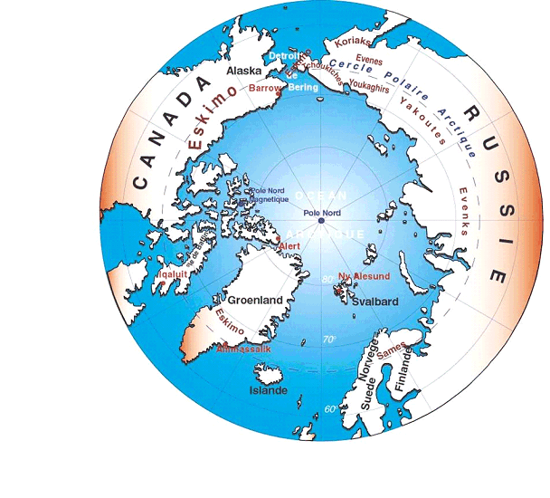
( Source : IPEV)
|
The legal status of the geographic North Pole The North Pole's location in the centre of an ocean, not to mention the fact that the Arctic coast is little or not at all inhabited, would seem to make it especially difficult to appropriate. Due to its very weak occupation, the Permanent Court of International Justice was therefore called upon to confirm Denmark's effective possession of Greenland (ruling of 5 April 1932). However, in 1909 - upon Peary's reaching the North Pole on 6 April 1909 - the president of the Canadian Supreme Court proposed applying the theory of sectors based upon the principal of contiguity. These sectors would be spherical triangles with the Arctic seaside of the adjoining nations as their bases, the east and west meridians of the coast's limits as their sides and the North Pole at 90° as their upper point. This idea was approved by the USSR in 1926. However, all the other bordering nations opposed this proposition, and the Arctic Ocean must be considered as being ruled by international maritime law, such as that defined by the Montego Bay Convention of 1982. The North Pole, therefore, is located in international waters. The Svalbard Archipelago is subject to a specific system. The Paris Convention of 21 October 1920 recognizes Norwegian sovereignty, but allows free access to all parties to pursue scientific as well as economic activities (mining). The Northeast and Northwest Passages are governed by more complex systems. The Northeast Passage was first opened by the explorer Adolf Erik Nordenskjöld in 1878. Russia does not recognize the right to freely move about in this area. Authorization and the payment of a fee are necessary to join a convoy following in the wake of an icebreaker. The Northwest Passage was first opened by the Norwegian Roald Amundsen in 1906. Following the passage of an American oil tanker on its way to Alaska in 1969, Canada adopted a specific law in 1970. This law requires ships to first obtain Canadian authorization to pass through a zone of 100 nautical miles 3 ( * ) (environmental protection zone) due to the danger and environmental risks of such navigation, as well as the difficulty of providing assistance. In 1985, the United States, which did not accept this position, sent a Coast Guard icebreaker to the area without first notifying Canada. The resulting diplomatic crisis led to the Ottawa Agreement of 1988 by which the two countries agreed to cooperate on security and environmental-protection issues and the United States agreed to the system of prior authorization. Finally, in 1992, Canada and Russia signed an agreement making the Arctic a special navigation and environment-protection zone, as set forth in Article 234 of the Montego Bay Convention. |
2. Antarctica
As opposed to the Arctic, Antarctica is a continent and not an ocean.
It was created by the breaking up of the Gondwana supercontinent 150 to 160 million years ago.
80 million years ago, during the Cretaceous Period, Antarctica was already centred on the South Pole. But its luxuriant flora and fauna, the fossils of which can still be found today, were tropical in nature. The first such fossils were found in 1902 by the Swede Otto Nordenjold. Antarctica remained connected to India and Australia for several tens of millions of years longer and up to 25 to 30 million years to South America.
Antarctica became further isolated with the formation of the Drake Passage. The Peninsula is now more than 1,000 km from Cape Horn and Adélie Land more than 2,700 km from Tasmania.
This isolation is the direct cause of a permanent east-to-west current in the ocean (the polar front) and in the troposphere which physically isolates Antarctica from the rest of the planet. This current can even be found in the stratosphere, but its direction varies according to the season. This sea current is 24,000 km long and 200 to 1,000 km wide and clearly separates the Antarctic from the other regions. Farther north, in a second circle, can be found the subtropical convergence marking the limit of the Antarctic Ocean, which covers a total of 76 million km 2 . This system of circumpolar circulations divided into two concentric frontal structures forms a veritable natural boundary with the planet's three other great oceans (the Atlantic, Indian and Pacific Oceans). The polar front and the subtropical convergence mark the boundaries of two zones whose oceans and climates are clearly distinct and are therefore home to different flora and fauna.
The complete glaciation of Antarctica was a slow process. It began some 30 million years ago, eventually forming a complete icecap from glaciers or small pre-existing caps. The icecap's form has apparently changed little over the past 15 million years, though it may have been larger, extending farther out to sea, or smaller 3 million years ago; however, ever since then, the icecap has remained remarkably stable.
From a geologic point of view, the western and eastern portions of the continent are fundamentally different. The eastern portion is thick (30 to 40 km) and very old (pre-Cambrian, or 3 to 4 million years old). The western portion is younger, undulating and volcanic. It is also thinner (25 to 30 km). In addition, the two portions are separated by a rift with active volcanoes such as Erebus 4 ( * ) , located in eastern Antarctica near the American base of McMurdo.
Eastern Antarctica, in particular the coasts of Adélie Land and George V (250 km), is the subject of studies to locate very ancient portions of the earth's crust dating from the Archean (2.5 to 4 billion years ago). This is especially interesting for French researchers because there is no rock in France more than 600 million years old. This should allow scientists to better understand the formation of the earth's first crust which was much thinner at the time and behaved differently. It will also allow researchers to identify the points at which Antarctica was connected to Australia.
Besides Antarctica, the Antarctic zone is almost exclusively oceanic. Indeed, up to the 65 th parallel, no 5° latitude section has more than 6.6% of its surface area above sea level.
|
Antarctica, from terra incognita to satellites Antarctica was for many years the terra incognita par excellence , for it had been dreamed, imagined and calculated for several hundred years before finally being discovered. Indeed, in the 5 th century B.C., it was imagined by the Pythagoreans to balance out their equations, just as it was starting in the mid-16th century, when the idea of a round earth was finally accepted. It was named in opposition to the Arctic, land of the polar bear, either because it has no bears ("land without bears"), or because the Great Bear constellation cannot be seen from there, or simply because it forms the North Pole's counterpart. During the 18 th century, various explorers would attempt to discover this unknown continent which many still imagined as welcoming and home to extraordinary creatures. Maupertuis said, "I would prefer to spend an hour conversing with a native of terra australis incognita than with Europe's greatest scholar . " 5 ( * ) Several explorers, such as Kerguelen, took various islands to be the headlands of a rich and prosperous continent. James Cook, who was the first to cross the Antarctic Circle on 18 January 1773 and to circumnavigate the Antarctic, pretentiously declared that since he was incapable of descending any further, either the continent didn't exist or it wasn't of any interest: "If any one should have resolution and perseverance to clear up this point by proceeding farther than I have done, I shall not envy him the honour of the discovery; but I will be bold to say, that the world will not be benefited by it". It was not until 1820 that Antarctica was finally discovered by the Russian Fabian von Bellingshausen sailing aboard the Mirny and Vostok , although he didn't actually disembark. The Frenchman Jules Sébastien César Dumont d'Urville, sailing aboard the Astrolabe and La Zélée , was the first to set foot on the continent in January 1840 and named the land that he discovered Adélie Land after his wife. The expedition's hydrographer, Vincendon Dumoulin, located the magnetic South Pole. The South Pole would be precisely located by the Shackleton expedition of 1909. The first permanent weather station, Osmond House, which is still in service, was set up in the South Orkney Islands in 1903. The Antarctic coast was gradually and slowly explored by Ross (1840-1842), Wilkes (1840), Filchner (1911-1912), de Gerlache, Scott and of course Amundsen, who conquered the South Pole on 14 December 1911. In 1912, the Australian Mawson discovered the first meteorite in Adélie Land. The systematic exploration of Antarctica didn't truly get under way until after the Second World War, thanks to technological advances. The American admiral Byrd conducted Operation High Jump, which allowed for the exploration of 3 million km² and the mapping of 60% of the coast. But the persistent lack of knowledge concerning Antarctica can be seen in the fact that at the time, a water route linking the Ross and Weddell Seas was still thought possible. In 1947, the French Polar Expeditions (EPF) were created by Paul-Émile Victor in order to explore Adélie Land and reaffirm French sovereignty of the region. The first station, Port Martin, was built for the 1949-1950 campaign and was occupied during the following three winters, up until 1952. Yves Valette and Bertrand Imbert were assigned the task of mapping the coastline. The International Geophysical Year (IGY) of 1957-1958 marked a decisive stage in the still incomplete exploration of the continent , for it led to the establishment of numerous and important permanent bases that are still occupied to this day (in particular, the South Pole and Vostok stations). It was chosen both to commemorate the 25th year anniversary of the 2nd International Polar Year and because it was a year of very great solar activity and the objective was to make significant progress in the space sciences, particularly in the field of magnetism. Under the direction of Bertrand Imbert, France built a new base, Dumont d'Urville, on the Adélie Land coast , to replace the Port Martin base that had been damaged by fire in 1952, and established the Charcot base 317 km inland at an altitude of 2,400 m. Jacques Dubois, Claude Lorius and Roland Schlich were the first to winter there, from February to November 1958. The IGY of 1957-1958 also saw the first trans-Antarctic crossing between the Ross and Weddell Seas, undertaken by the team from Britain and New Zealand led by Vivian Fuchs and Edmond Hillary (99 days, 35 persons, 17 vehicles and 4 planes over 2,700 km), thereby realizing the dream that Shakleton was unable to fulfill in 1915 aboard the Endurance . While today Antarctica has been completely mapped thanks to satellites, it has yet to be completely explored by man. |
The Antarctic continent and its permanent, floating ice shelves represent a surface area of 14 million km 2 , greater than the total surface area of Europe and one and a half times that of China and 8% of all above-sea-level land.
It's divided into two distinct parts lying east and west of the trans-Antarctic mountain chain that extends for more than 4,000 km and rises above 5,000 m (Mount Vinson = 5,140 m). To the west is the Antarctic Peninsula. The continent's most northerly portion extends beyond the polar circle (63° latitude). To the east lies the glacial plateau, a gigantic dome of ice rising to a height of 4,000 m.
Taking into account the entire continent, the average thickness of the ice is 2,200 m, though it can be over 4,000 m in areas. For instance, the ice is 4,776 m thick beneath the Charcot station in Adélie Land's Astrolabe Bassin. The greatest recorded thickness, 4,804 m, was measured between Concordia and Vostok.
Antarctica stores 30 million km 3 of ice: this represents 2% of the earth's water, 75% of its fresh water and 90% of its ice. The complete melting of Antarctica would raise the Earth's sea level by 60 to 70 m.
The colossal weight of the icecap (30 million billion tons) pushes the bedrock down some 700 m. This phenomenon is known as isostasy. Mapping has shown the bedrock to lie beneath sea level. This is especially true in the west, where the bedrock is often to be found at -1,500 m. Antarctica is therefore an archipelago. This characteristic could significantly impact the warming process of this continent since its ice is in direct contact with the oceans. More generally speaking, the bedrock's tortured and little understood morphology effects the flowing out of the ice, the dynamics of the icecap and even the formation of cold waters since the geography of the continental plateau is greatly marked by the oldest glaciers. In addition, it is especially striking to consider the fact that erosion seems to be insignificant in Antarctica, because of such ancient, stable and slow glaciers.
The floating ice shelves cover half of the coastline. Two are especially important: Ronne-Filchner in the Weddell Sea (473,000 km 2 ) and Ross in the Ross Sea (526,000 km 2 ), the second covering the same area as France. They play a fundamental role in the outflow of the icecap's ice, forming sorts of flying buttresses, and in the formation of cold, deep waters which feed the Earth's oceans. In the distant past, their formation was undoubtedly the key to the glaciation of the entire western part of the continent, transforming the archipelago into a single, unified icecap.
During the austral winter, our regions' summer, the ice shelf covers an extra 15 million km 2 , brushing the geographic limit marked by the circumpolar current.
Antarctica is a continent of extremes. It is the coldest, windiest and most barren continent.
· The cold
The cold is due first and foremost to the inclination (the word "climate" comes from the Greek word "klima", meaning inclination) of the Earth, which in the winter results in long nights and in the summer in a rather feeble warming because of the slight impact of the sun's rays. There is also the "albedo" effect, by which the snow and ice reflect back into the atmosphere most of the sun's rays and therefore most of its heat.
Antarctica's continental structure also plays an important role, for it prevents the sea and air currents from coming to warm the continent; at the same latitudes, the difference in temperature between the Arctic and Antarctica has been estimated at 10°C.
One must also consider the continent's relatively high altitude. At 3,000 m, the temperature is some 20°C cooler than at sea level.
Indeed, the coldest recorded temperature was recorded in the heart of eastern Antarctica: - 89.6°C at Vostok, on 21 July 1983.
· The wind
Antarctica is also the world's windiest continent, because the air cools and condenses upon contact with the icecap. This phenomenon is explained by the impossibility of the air to escape by rising up due to the very low altitude of the temperature inversion layer. Therefore, it is forced to descend to the coast, creating the katabatic winds.
While these winds are rather weak on the plateau, they become much stronger when they arrive at the coast due to the difference in altitude. Indeed, they go from an average speed of 11.5 km/h at Concordia on Dome C to 22.3 km/h mid-route to 40 km/h at the French station of Dumont d'Urville. The world's wind record was recorded at Cape Denison (George V Coast) at 329 km/h. The former French station of Port-Martin recorded an average annual wind speed of 70 km/h; during eleven days, the winds there exceeded 180 km/h!
These winds play an important role in spreading and stratifying the icecap's snow. They also result in "sastruggi", small snow banks about a metre in height which render travel by snowmobile very difficult and are the cause of significant equipment breakage.
· The barrenness
Antarctica is also one of the world's most barren regions due to its extremely low rainfall: 2 to 3 cm in the centre, such as at the Concordia base, and only tens of centimetres along the coast.
In contrast, the plateau of Eastern Antarctica receives in one year the same rainfall as the Parisian basin receives in a single month: 5 cm of water.
The heart of Antarctica is completely void of any plant or animal life.
B. FRANCE'S RESPONSIBILITY IN THE ANTARCTICA TREATY
Antarctica is governed by a unique legal system which was established by the 1959 Treaty of Washington. It dedicates the continent to science and peace.
1. The origins of the treaty and the Antarctic system
· The origins
Following various discoveries, seven nations each successively claimed an angular portion of Antarctica: the United Kingdom in 1908, New Zealand in 1923, France in 1924 with Adélie Land, Australia in 1933, Chile in 1940 and Argentina in 1943.
For the United Kingdom, France and Norway, these claims were based on the principle of discovering lands under the sovereignty of no nation ( res nullius ).
However, Chile and Argentina based their claims on the theory of territorial contiguity. The Peninsula was seen as the continuation of their territories farther south, drawing a geologic analagoy between the Andes and the trans-Antarctic chain.
In the 1940s and 1950s, these claims gave rise to interstate conflicts. The British launched Operation Tabarin in 1943 in response to German activities. They established four bases which, at the end of the war, were placed under the authority of the Falkland Islands Dependencies Survey (FIDS), under the aegis of the Foreign Office. On 18 January 1949, the Argentines and Chileans exchanged fire on the Peninsula. What's more, the United Kingdom decided to take its territorial conflicts with these two countries before the International Court of Justice in 1955. The case would be removed from the Court in 1956.
But the conflicting claims of these nations seeking to appropriate various portions of Antarctica ran up against several important obstacles.
The Third World had just arisen - the Bandung Conference having taken place in 1955 - and refused to accept that the old colonizing countries share out amongst themselves this new continent.
More important still were undoubtedly the respective positions of the United States and the USSR, neither of which claimed any territory nor recognized any claim and both of which desired to be able to establish themselves there freely. They therefore imposed an "open door" policy which would allow them - in any case, the other countries would have been powerless to prevent them - to set up bases in Antarctica (South Pole, Palmer and McMurdo for the United States).
This philosophy would be firmly established during the International Geophysical Year of 1957-1958. During these 18 months, the principal permanent bases were established and the culture of international cooperation unique to Antarctica was forged.
· The treaty
The Antarctic Treaty was signed in Washington on 1 December 1959 by 12 nations. It came into effect on 23 June 1961. Today, it includes 46 parties, including 28 consultative parties.
It establishes "a functional internationalization of the continent, founded upon both its use for peaceful purposes and the suspension of all territorial conflicts." 6 ( * )
The treaty applies to all territories located south of 60° South.
It forever dedicates Antarctica to only peaceful activities.
Military activities, nuclear tests and nuclear waste are banned by Article 5, in the interest of all mankind.
These peaceful activities are science and international cooperation, as specified in the preamble and in Articles 2 and 3: " Convinced that the establishment of a firm foundation for the continuation and development of such cooperation on the basis of freedom of scientific investigation in Antarctica as applied during the International Geophysical Year accords with the interests of science and the progress of all mankind. "
The treaty also ensures the territory's internationalization. Article 4 "suspends" any territorial claims. The nations can maintain their claims, as nothing in the treaty can be interpreted as a renunciation of their rights. However, nothing in the treaty forces the other nations to recognize these claims. Those nations without possessions cannot make any claim.
The treaty assigns the management of Antarctica to a small group of nations: the consultative parties.
While the Antarctic Treaty is open to all countries, only certain nations are able to actively participate in the continent's management. These are the consultative parties. A nation is considered a consultative party as long as it " demonstrates its interest for Antarctica by conducting substantial scientific research there, such as the establishment of a scientific station or the dispatch of a scientific expedition. "
They gather together during the Atlantic Treaty's Consultative Meeting (ATCM). This body has the power of issuing recommendations which to date make up a body of some 200 documents and are the rules to be respected by the Antarctic operators.
The respect of the treaty is guaranteed by a system of observers with access to the bases. This clause of Article 7 is no longer applied in the spirit of the Cold War, but rather to encourage scientific cooperation. It amounts to evaluating the various countries' stations and their scientific potential. The French station of Concordia was evaluated in this manner during the austral summer of 2006-2007.
This "aristocratic" status has long been criticized by several Third World nations that would prefer that the management of Antarctica be transferred to the UN.
· The "Antarctic system"
The "Antarctic system" generally refers to all conventions and organizations - other than the Madrid Protocol - that have been added to the original treaty.
It consists of three conventions dealing with environmental protection:
- The Convention for the Conservation of Antarctic Seals
(CCAS) was signed on 1 June 1972 in London and came into effect in 1978. It forbids the hunting of seals.
- The Commission for the Conservation of Antarctic Marine Living Resources (CCAMLR), signed in Canberra (Australia) on 20 May 1980, came into effect on 7 April 1982. It specifies the protected areas and ensures the management of marine resources. Its jurisdiction extends beyond 60° South.
- The Agreement on the Conservation of Albatrosses & Petrels (ACAP), signed in Cape Town on 2 February 2001, came into effect on 1 February 2004.
In addition to these conventions are various organizations dedicated to science in Antarctica. The two main organizations are:
- the Scientific Committee on Antarctic Research (SCAR), created in 1957 to coordinate the IGY. Its first president was Georges Laclavère, a member of the French Academy.
Its headquarters are in Cambridge and the Scott Polar Research Institute is in charge of its secretarial work. Its mission is to gather together the scientific community in order to define the main themes of scientific research in Antarctica. In addition, it now has its Arctic counterpart in the form of the International Arctic Scientific Council (IASC), created in 1990.
SCAR's scientific activities are organized around five international programmes:
- Subglacial Lake Exploration (SALE);
- he Antarctic and the Global Climate System (AGCS);
- The Antarctic Climate Evolution;
- Evolution and Biodiversity in the Antarctic (EBA);
- Interhemispheric Conjugacy Effects in Solar-Terrestrial and Aeronomy Research (ICESTAR).
- The Council of Managers of National Antarctic Programmes (COMNAP) was created in 1988. It gathers together the directors of polar institutes from 29 countries, who coordinate their activities and organize their cooperation. Its current president is Mr. Gérard Jugie, director of IPEV (French polar Institute-Paul-Emile Victor).
Finally, the temporary offices set up to organize the international polar years can also be considered of importance. The defining of themes and the selection/certification of programmes which play a role in the structuring of research and maintaining the spirit of cooperation unique to Antarctica.
|
The International Polar Years and the 2007-2008 Polar Year The International Polar Year is a major scientific event. It only occurs every 50 years or so. The first took place in 1882-1883. It was inspired by an initial, successful international collaboration in 1874-1875 between France, the United Kingdom, Germany and the United States to observe the passage of Venus from the sub-Antarctic islands. The Austrian explorer and geophysicist Karl Weyprecht therefore put forward the idea of organizing an international polar year to study geophysical and astronomic phenomena. Twelve countries agreed to organize fifteen simultaneous expeditions, thirteen to the Arctic and two to the Antarctic (South Georgia and Tierra del Fuego). One objective was to once again observe the passage of Venus (6 December 1882). On the heels of this new success, the International Physics Congress held in London in 1895 decided to organize a polar year every 50 years. The World Meteorological Organization launched the second IPY in 1932-1933 to study the planetary implications of the newly discovered jet streams. More than 40 countries participated, which allowed for important progress to be made in the fields of meteorology, geomagnetism, the atmospheric sciences and the cartography of ionospheric phenomena. 114 observation stations were established in the Arctic, and the first station in the Antarctic interior was built by the American admiral Byrd, who wintered there alone on the Ross Ice Shelf. France established a winter station at Scoresby Sund in Greenland. The last IPY was the International Geophysical Year of 1957-1958, which gathered together 61 countries. Three high-atmosphere physicians were largely responsible for its organization: Lloyd Berkner, Sydney Chapman and Marcel Nicollet. They wanted to take advantage of the radars that had been perfected during the Second World War, as well as of the future satellites during a year of exceptional solar activity. An international research programme was therefore established to collect data on the high atmosphere, the icecaps and continental drift, as well as on the volume of fresh water in the form of Antarctic ice, seismology and meteorology. 45 research stations were set up in Antarctica and the sub-Antarctic islands. Indeed, during this IGY, the physicist Van Allen demonstrated that solar wind particles are channeled in the polar regions by the magnetic field's lines of force and it is the shock of these high-energy particles colliding with our atmosphere that results in the formation of aurora australis and borealis. The 2007-2008 International Polar Year will therefore be a very important event. At an especially critical time in the world's history, considering the current climate change, a principal objective of the IPY will be to better understand the polar regions' role in global equilibriums through the organization of an intense research campaign. The IPY enjoys the support of more than 60 countries and nearly twenty international research organizations, including the International Council for Science (ICSU) and the World Meteorological Organization (WMO). The IPY is managed by the British Antarctic Survey in Cambridge and its director is Prof. Chris Rapley. At the French level, the IPY is organized by the Academy of Sciences and IPEV, under the direction of Claude Lorius and Yves Frénot. More than 200 research projects have been selected. Six main themes have emerged: - Inventory: Determining the current environmental situation of the polar regions. What is the status of the circulation and the oceanic composition in the high latitudes? How do the polar ecosystems vary in time and space? To what extent can these variations be explained by anthropogenic impacts? How is the climate changing? - Evolution: A quantification and understanding of the natural, environmental and social evolution, past and present, in the polar regions, as well as a fine-tuning of future projections. How does the polar regions' biodiversity respond to climate changes in the long term? How does the planet respond to successive glacial cycles? What are the polar regions' cooling factors? - Planetary interactions: A better interpretation of the connections and interactions that exist between the polar regions and the rest of the world. What role do the polar regions play in the global carbon cycle? How stable are the large bodies of ice and what impact do they have on sea level? What are the North-South interconnections? - New frontiers: Study the limits of science in the polar regions. What are the characteristics of the deep oceans and sub-glacial ecosystems? - A privileged position: Utilization of the polar regions to create Earth-based observatories to study the sun and cosmos. - The human dimension: The durability of circumpolar societies. |
2. Mining a suspended issue
Ever since the 1980s, the economic exploitation of Antarctica has become an ever more important issue, in particular with regard to mining.
The handful of explorations undertaken at the time and the knowledge acquired on continental drift would suggest that Antarctica harbors immense mineral resources. Indeed, considering the links that exist between Antarctica and the Andes, South Africa and Australia, it's not difficult to imagine the combined mineral riches of these three zones awaiting discovery in Antarctica. In addition to these mineral resources, the continent could harbor oil and gas reserves due to the existence of sedimentary plateaus.
To open Antarctica to oil and mineral exploration and development, the signatories to the Antarctic Treaty negotiated during six years the Wellington Convention, which was signed on 2 June 1988 . This convention regulates in a very strict manner these activities and was seen by many as being a lesser evil than uncontrolled development.
This failed to take into account the mobilization undertaken by Commander Jacques-Yves Cousteau, who led the Antarctic and Southern Coalition international campaign.
Under these circumstances, in June 1989, the Bureau of the National Assembly commissioned the Parliamentary Office for the Evaluation of Scientific and Technological Choices to evaluate the economic issues and ecological risks related to mining research and development. Mr. Jean-Yves Le Déaut, Deputy, was chosen as the commission's rapporteur and was able to attend the ATCM of October 1989 in Paris.
In June 1989, the President of France, François Mitterrand, after having received the report that he had requested from Commander Cousteau, decided to submit to the French Government his proposal to make Antarctica a nature reserve in which mining would be completely banned. Soon afterwards, the Prime Minister, Michel Rocard, announced that France would not ratify the Wellington Convention.
In August 1989, France was joined by Australia. In December 1989, the Parliamentary Office rendered its conclusions public. In 1990, Italy and Belgium joined France and Australia; together, these four countries favoured negotiating a new agreement. Two years later, on 4 October 1991, the Madrid Protocol was signed. It came into effect on 14 January 1998.
This protocol named Antarctica a "nature reserve dedicated to peace and science" (Article 2).
It forbids any mining activity for 50 years (Article 7), and this ban can only be lifted by a unanimous vote of all parties.
All activities on the continent must first be approved by the competent authorities of each signatory nation (Article 8). For France, the TAAFs are assigned this responsibility. In addition, a Committee for the Polar Environment was created under the auspices of the treaty system.
Specially protected zones can be established for the flora and fauna.
The Madrid Protocol was integrated into French law by Act No. 2002-347 of 15 April 2003 and Decree No. 2005-403 of 29 April 2005. These texts have been included within Title VII of the French Environmental Code.
The system of prior authorization suffers from important limits: every national authority is qualified to make rulings in its specific claim zone with respect to not only its own nation's citizens, but also the citizens of the other "possessioned" nations; this means that it is possible to seek the approval of those domestic or foreign authorities deemed to be the most flexible. Above all, it amounts to only a procedural obligation . There are no common, fundamental rules governing the decision-making process. Most of the consultative parties cannot prevent one of their number from pursuing an environmentally-harmful activity.
Indeed, this is the case with regard to Russia's desire to penetrate the sub-glacial lake of Vostok , or at the very least to provoke an upwelling of water to be withdrawn once frozen. The scientific community strongly doubts that Russia has perfected a method that poses no risk of contamination . Despite statements to this effect formulated by various parties, the Russians are going ahead with their programme, convinced of the harmlessness of their method and the scientific interest of such sampling and they refuse to transfer this activity to another, smaller lake located more on the continent's periphery.
Indeed, this lake, of nearly the same size as Corsica, is the largest known sub-glacial lake in Antarctica 7 ( * ) . Many researchers feel that it should be preserved and that the samples of frozen water will be of little scientific interest; the threat of contamination posed by such sampling is even greater now that it is believed that the lakes form an interconnected network linked together by channels of melted water beneath the icecap.
Indeed, the heat of the bedrock combined with the pressure of the moving ice results in the bottom of the icecap melting. This water can, depending on the relief, be concentrated to form sub-glacial lakes which, along with their tributary channels, contribute to the process of the glaciers flowing out to the sea. Many believe that they play an important role in the speed of the outflow and therefore in the overall state of the Antarctic ice mass.
But what draws the attention of the Russian researchers on Vostok and motivates this sampling is the existence of unknown life forms. What life can exist 3,500 m below the ice? How did it develop? How old is the water?
The first hypothesis was that the lake's water was more than 400,000 years old, because the Vostok ice core enabled scientists to go back that far. This would have meant that the lake was effectively sealed and that any life it contained would have been at least as old, even going as far back as the Antarctic glaciation. However, the most recent studies tend to call this hypothesis into question. The water would appear to be very old, certainly more than 100,000 years, but the lake is not a closed environment.
Exchanges exist with the icecap. A process of melting and regelation exists. There is a circulating current. There may also be openings to other lakes. The life that exists within the lake is indeed very old, but it must be better understood to have a more precise idea of its age. Researchers believe that these life forms can yield important information regarding the origins of life on Earth and perhaps the type of life that may exist beneath the icecaps of other planets.
These hypotheses are based on the discovery in the regelation ice at the bottom of the Vostok sample of a thermophile bacterium, Hydrothermophilus thermoluteolus , which lives on hydrogen. This bacterium is only found in three places on Earth (Japan, the United States and Australia). Do similar hot springs exist at the bottom of Vostok Lake? How is this bacterium related to the other known bacteria? What else awaits discovery?
In addition, these mechanisms must be accompanied by measures to deal with ecological emergencies linked to such accidents as the January 1989 shipwreck of the Argentine tanker Bahia Paraiso, whose 700 tons of oil polluted 100 km². Likewise, it took 17 years to completely eliminate the consequences of the 1972 cooling-system leak of the McMurdo nuclear reactor built in 1962.
3. Tourism: a new peaceful threat?
In Antarctica, the growth of tourism has become a subject of concern. In 2005, an estimated 23,000 tourists visited Antarctica, as compared to only 6,700 in 1992.
Tourism on the continent is growing exponentially. The first tourist flight to Antarctica was an overflight in 1956 from Chile. The first cruise to Antarctica took place in 1957-1958. In 1990, the 50,000 th tourist visited Antarctica, but the 100,000 th arrived in 1998 and the 200,000 th most likely set foot on the continent in 2006.
A worrying parallel can be drawn with the Falkland Islands. The arrival of ships carrying more than 1,000 passengers greatly opened these islands to tourism. In 1994-1995, only 5,000 persons visited these islands each year; in 2000, there were almost 40,000 visitors.
The same trend could today take place in Antarctica, with important consequences on the continent's flora and fauna. Indeed, the time of basic cruises for a very limited number of passengers is over. There are an ever greater number of ships with more than 3,000 passengers sailing to Antarctica, which allows operators to offer cruises for as little as €5,000.
This trend runs counter to the recommendations of the International Association of Antarctica Tour Operators (IAATO), created in 1991 upon the initiative of the NSF 8 ( * ) and American tour operators. This organization tries to limit tourism's impact by pursuing an educational policy, respecting biological non-proliferation measures (foot baths), and respecting the continent's animal life (preventing visitors from getting too close to the animals).
Tour operators also have a real interest in preserving the wild character of these cruises, by never having more than one boat at the same site and limiting the number of disembarking tourists via rotations.
Nevertheless, most of the tourist activity is concentrated around some fifty sites on the Peninsula where the continent's animal life can be easily observed, thereby creating inevitable problems.
Today, there are real causes for concern. There is a strong temptation to increase the passenger capacity of the tourist ships. However, the greater the number of passengers, the more difficult it will be to carry out any sort of regulation. A certain growth is inevitable: several boats at the same site, an increase in the number of disembarked passengers, an artificialization of the sites for their protection (footbridges, etc.), even the construction of a permanent tourist infrastructure and in all likelihood of hotels. What consequences will all of this have on the flora and fauna and on the scientific research? The Australians have already demonstrated that Adélie Land's penguins have been contaminated with viruses by their contact with the bases.
Scientists operating on the Peninsula are increasingly concerned by the influence tourism may have on their bases' activities, because it necessitates specific measures in order to manage visits and avoid disturbances. During accidents, logistical means meant for research must also be mobilized. Getting about in Antarctica is obviously complicated, costly and often dangerous.
So far, France has been relatively protected from this influx of tourists thanks to Adélie Land's isolated location.
The sub-Antarctic islands are accessible via the Marion Dufresne during its annual rounds. Tourism remains very limited and its growth is undoubtedly restrained by the tediousness of moving about in the area, with all journeys taking place by sea.
Nevertheless, the situation is quite unique, with a public authority playing the role of tourist operator, at the risk in certain cases of assuming the financial consequences. This was notably the case in 1999-2000, when a millennial cruise that had been organized turned out to be a complete failure. Indeed, as related by the Controller and Auditor General in its 2005 public report, only 4 passengers (among 38 available seats) had reserved and paid for their trip. "Most of the passengers were already connected to the territory in some manner and the great majority didn't have to pay for the cruise . " The total cost of this operation came to €730,000 of the taxpayer's money! Happily a one-off event, such a situation shows the limits of a tourist operation organized by a public authority rather than by a private operator acting at its own risk.
The question now concerns the development of tourism in Adélie Land . Tourist cabins are being planned for the Astrolabe , as is a "tourist-scientific tour" at the Dumont d'Urville station, with the active participation of the researchers present in an open-door, educational programme.
Your rapporteur is firmly opposed to any such projects, should they be proposed.
First of all, such projects are simply unrealistic , considering the great discomfort of a two-week, round-trip journey on the Astrolabe , in very rough seas, in a vessel with a flat bottom because of the ice!
It is shocking to want to make changes - to the Astrolabe and the Dumont d'Urville base - for the safety or comfort of tourists, when such changes would be first and foremost necessary for the researchers.
Likewise, it doesn't make sense to give a few tourists - rather than the scientists - priority access to the limited logistical means available for the carrying out of scientific work at sea or far from Dumont d'Urville (in other words, the Astrolabe and its helicopter).
It is also shocking to want to transform a scientific base into a tourist attraction , by obliging the scientists to give tours of their living areas and laboratories and even to allow the tourists to participate in their work. No laboratory in France is subjected to such an obligation.
Finally, if one persists in wanting to open this station to tourism and to impose such a change on the scientists, one must then consider the great consequences that such a decision would have on our credibility within the Antarctic system , even though our country was at the origin of the continent's total protection.
Clearly, the development of tourism should not be completely excluded from Adélie Land. However, should the local government be organizing tourist activities using logistical means originally meant for scientific research?
In the opinion of your rapporteur, the answer is clearly no, it should not.
* 1 Découverte Gallimard, Paris, 159 p., 1st edition 1987, 2nd edition 2006.
* 2 See Les milieux polaires, by Mr. Alain GODARD and Ms. Marie-Françoise ANDRÉ (Armand Colin, Collection U, Geography, Paris, 1999, 455 p., Chapter I).
* 3 1 nautical mile = 1,852 metres.
* 4 Named after the ship of its discoverer, James Clark Ross.
* 5 See Le grand défi des pôles, Bertrand Imbert and Claude Lorius, 2nd Edition 2006, p.30.
* 6 Jean-René Dupuy, AFDI, 1960.
* 7 More than one hundred lakes have been discovered. Vostok Lake has a surface area of 14,000 km².
* 8 The National Science Foundation of the United States (equivalent to France's CNRS) - Office of polar programmes.