


SENAT
Report n° 117 (2007-2008) by M. Roland COURTEAU, Senator (for the parliament office for the evaluation of scientific and technological choices) - Appendix to the minutes of the 7 December 2007 session
Disponible au format Acrobat (21 Moctets)
c) The French model in Polynesia
(1) CEA at the heart of the Polynesian warning system
The creation of a national tsunami warning centre in Polynesia is directly linked to France's nuclear activities in the Pacific.
Set up by CEA ("Atomic Energy Commissariat") in the beginning of the 1960s, France's geophysical laboratory (or "LDG") in Tahiti has, since 1964, been responsible for providing information on those tsunamis liable to affect the coasts of French Polynesia. For this reason, it set up the Polynesian seismic network and has developed ever more advanced methods for evaluating the tsunami-generating potential of earthquakes.
Today, the activities of the Pamatai geophysical laboratory can be divided into three categories:
Firstly, within the framework of the Comprehensive Nuclear-Test-Ban Treaty, LDG/Pamatai is part of the international nuclear-explosion monitoring system.
Secondly, LDG/Pamatai's seismic network for Polynesia is responsible for the round-the-clock monitoring of French Polynesia's seismicity; this includes earthquakes, underwater volcanoes, landslides and storm surges. Within this framework, since 1962, LDG/Pamatai has made use of 9 seismic stations located in Tahiti, Rangiroa, Tubuai and Rikitea.
Finally, LDG/Pamatai manages the Polynesian tsunami prevention centre, which ensures 24-hour tsunami monitoring for the Pacific zone, in partnership with PTWC.
|
The Comprehensive Nuclear-Test-Ban Treaty This treaty, adopted on 10 September 1996 and signed by 71 countries (including the 5 official nuclear powers) on 24 September 1996, forbids nuclear testing. It complements the treaty of 5 November 1963, which prohibs underwater, outer-space and atmospheric nuclear testing, by extending the ban to underground testing. This treaty set up an international monitoring system for the air, water and oceans via stations scattered throughout the world. Stations for detecting radionuclides (airborne radioactive elements) and infrasonic vibrations are used for the atmosphere. Seismometers are used to detect seismic waves generated by earthquakes or underground explosions. These sensors can also be used to monitor the oceans, by detecting and identifying propagating hydroacoustic T waves. DASE 23 ( * ) , which oversees LDG/Pamatai, is responsible for France's contribution to the international monitoring system (IMS), with regard to the various technologies (seismic, radionuclide, infrasonic-vibration and hydroacoustic) used. The Polynesian geophysical network includes IMS stations whose data is sent to DASE and the international data centre in Vienna. Due to its central location in the Pacific, the seismic station in Tahiti is a key site for seismic and hydroacoustic monitoring. The radionuclide-analysis station is located at the Pamatai site. Two infrasonic-vibration stations are located in Taravao (on the Tahitian peninsula) and the Marquesas Islands. Source: DASE |
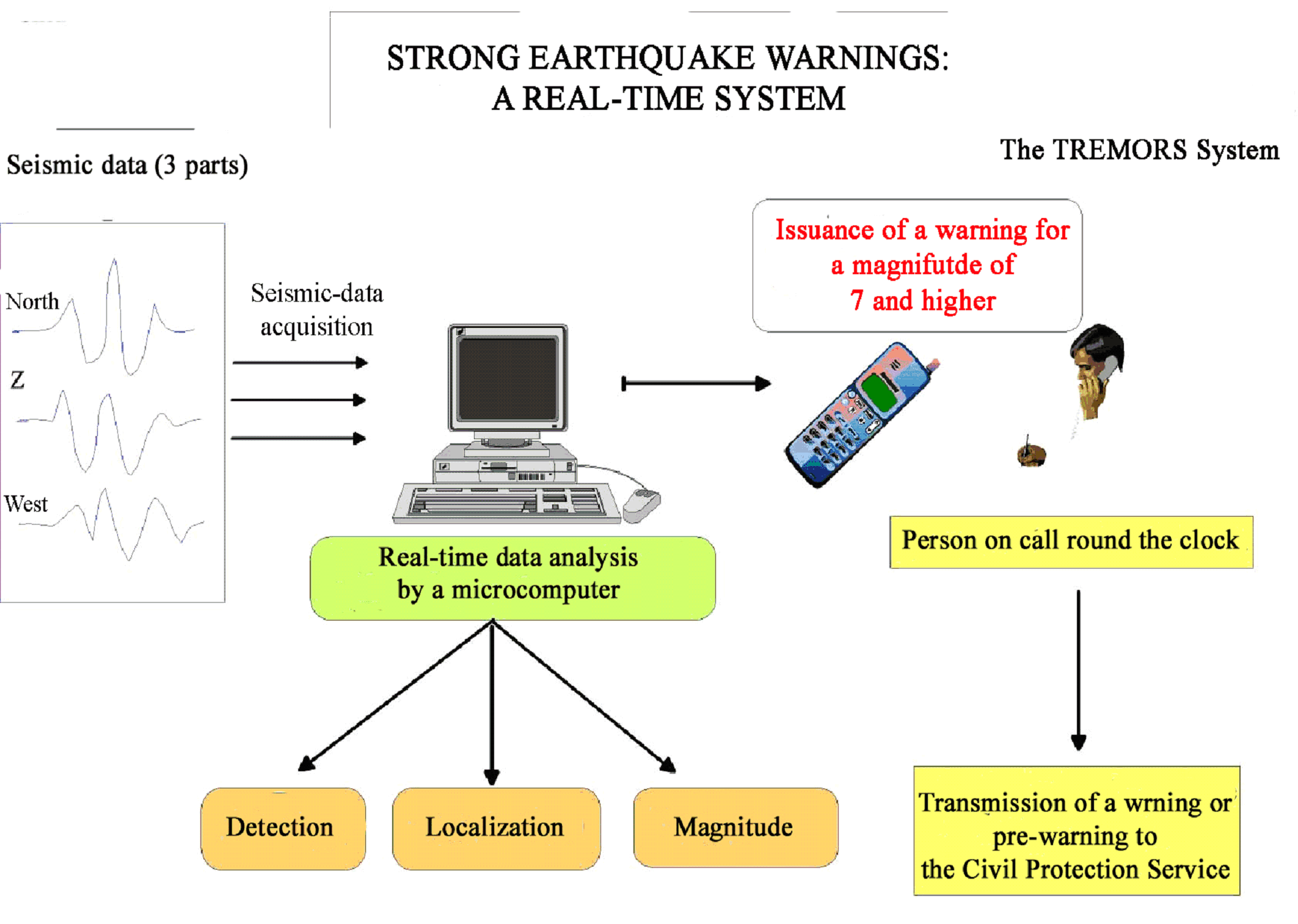
When LDG/Pamatai detects an earthquake with an underwater focus less than 60 km deep and a magnitude of 7 or greater, it informs the State Authority and the civil protection service.
It should here be pointed out that LDG/Pamatai has developed a highly effective system for the automatic, real-time detection and localization of tsunami-generating earthquakes called TREMORS® 24 ( * ) (Tsunami Risk Evaluation through seismic MOment from a Realtime System).
The energy released during an earthquake constitutes its "magnitude". The greater the magnitude, the more energy released by the earthquake. It consists of a logarithmic scale; in other words, an increase of 1 step corresponds to a 30 fold increase in the amount of energy released. While the Richter Scale (Ms) is the best known magnitude scale, it has the disadvantage of becoming saturated in the case of a strong earthquake: the magnitude reaches a ceiling that it has difficulty passing, even while the amount of released energy continues to increase. To solve this saturation problem, the moment magnitude scale (Mw) was developed in the 1980s. This scale is in line with the Ms scale and acts as its extension for earthquakes of greater magnitude, so as to avoid the saturation effect. For example, the earthquake of 22 May 1960 in Chile had a magnitude of 8.4 on the Richter Scale and a magnitude of 9.5 on the Moment Scale. Therefore, it was in fact 30 times greater than the instruments indicated at the time.
Using the Richter Scale to measure the magnitude of strong earthquakes can result in greatly underestimated tsunami forecasts. That is why a precise measurement of magnitude is essential. However, according to the information obtained by your rapporteur, the Moment Scale requires numerous seismic stations and considerable calculation means.
To overcome these difficulties, LDG/Pamatai has introduced a new magnitude scale, the Mm (Mantle Scale), which avoids the saturation effect plaguing the Richter Scale and requires only one seismic station. Beyond a certain magnitude threshold (currently set at 7), a warning is issued by GMS to the geophysicist on duty.
Source: CEA/DASE/LDG/Pamatai
In addition, LDG/Pamatai uses four tide gauges installed in Papeete (1), the Gambier Islands (1) and the Marquesas Islands (2). Only one of these stations was financed by France via a FIDES project ("Investment Fund for Socio-Economic Development"). It also receives data from some twenty tide gauges installed, for the most part, in the South Pacific on islands located between the tsunami-generating zones and French Polynesia.
These activities are complemented by studies and simulations meant to better evaluate the tsunami hazard in Polynesia (see above).
It is not surprising that CEA represents France at the ICG/Pacific, for which it has assumed first the vice-presidency, then the presidency, and that it was actively involved in establishing the specialized tsunami emergency plan ("PSS") for French Polynesia 25 ( * ) .
* 23 The Département Analyse, Surveillance, Environnement ("Department of Analysis, Surveillance and the Environment") of CEA ("Atomic Energy Commissariat").
* 24 This trademark was first registered with the INPI in 1994 and was renewed in 2004 for a further 10 years.
* 25 This plan defines the missions and responsibilities of all concerned services in the event of a tsunami warning and establishes the steps to be taken to evacuate the population, if need be.