


SENAT
Report n° 117 (2007-2008) by M. Roland COURTEAU, Senator (for the parliament office for the evaluation of scientific and technological choices) - Appendix to the minutes of the 7 December 2007 session
Disponible au format Acrobat (21 Moctets)
(2) A warning system based on a deep understanding of tsunamis
As has already been pointed out, the effectiveness of any warning system depends on a good prior understanding of the hazard. That is why several studies were entrusted to CEA, in order to produce a tsunami map.
The analysis of earthquakes in the Pacific zone between the years 1837 and 2005 suggests that the Polynesian coasts were touched by at least 15 tsunamis during this period (11 of which caused damage and 2 of which were deadly).
The tsunami risk in French Polynesia
Source: CEA/DASE
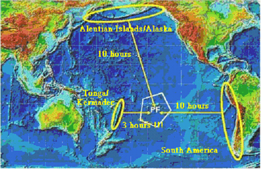
Only exceptionally strong subduction earthquakes (an Mm magnitude greater than 9) threaten to generate a transpacific teletsunami that could endanger all of Polynesia. The main subduction zones capable of producing such an earthquake are those of the South American coast (Chile, Peru), the Aleutian island arc and the Pacific Northwest (the Kuril island arc, Japan, Kamchatka). However, with regard to the last zone, the risk would seem to be less great, insofar as Polynesia lies outside the area of maximum effect for tsunamis originating in this zone.
Therefore, we can identify three seismic zones liable to generate the most devastating tsunamis:
- The South American coastal zone (Chili, Peru). It should be pointed out that a seismic gap exists north of Chile: sometime in the next 20 to 30 years, a magnitude 9 earthquake is expected to occur in this zone, generating a particularly destructive tsunami in the Marquesas Islands, with simulations predicting a wave 11 metres high and inland penetrations of up to 1 km on the island of Hiva Oa;
- The Aleutian island arc;
- The Tonga-Kermadec zone to the west. The seismic history of this region is not well known, but computer simulations suggest that a devastating tsunami originating in the Tonga Archipelago could touch French Polynesia. In addition, a seismic gap has been identified in the Kermadec Islands, suggesting that a strong earthquake is to be expected in this zone.
Moreover, on-site observations and computer simulations reveal a strong variation of the tsunami hazard depending on the islands, as shown in the following map prepared by CEA:
French Polynesia tsunami exposure levels
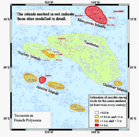
Source: CEA/DASE
The Marquesas Islands appear particularly vulnerable to tsunamis, because they can be affected by major tsunamis more than 4 times per century. What's more, tsunamis generated by earthquakes off the South American coast are significantly amplified in this area. For example, during the magnitude-7.3 earthquake off the coast of Peru on 21 February 1996, a tsunami of 2-3 metres was observed in the Marquesas Islands, compared to only 10 cm in Papeete. This amplification is linked to the local bathymetry: these islands have gently sloping underwater reliefs and are not protected by coral reefs.
In the Austral Islands, the island of Rurutu is also liable to be touched twice per century by tsunamis. The other islands are protected by the barrier reef, thereby mitigating the effects of tsunamis.
As for Tahiti, this island is relatively protected by its coral reef, except for its north and northeastern coasts.
The map indicating those zones likely to generate the most devastating tsunamis for French Polynesia and the tsunami exposure level map have both served as references in setting up the warning system.
As for the American and Japanese systems, the warnings are divided into different risk levels. Three colour codes have been defined, according to the seriousness of the threat.
The level 2 warning (yellow) is set off by earthquakes with an Mm magnitude of greater than 8 and when the tsunami's estimated time of arrival on the Polynesian coasts is announced less than 9 hours in advance. In this case, LDG/Pamatai notifies the civil protection service and the High Commissioner.
The level 3 warning (orange) is set off by earthquakes with an Mm magnitude of between 8.7 and 9 and when the tsunami's estimated time of arrival on the Polynesian coasts is announced less than 6 hours in advance. In this case, the threat of a tsunami is certain and all local authorities are informed.
Finally, the level 4 alert (red) is set off either by an earthquake with an Mm magnitude of above 9, or when the tsunami's expected time of arrival on the Polynesian coasts is announced less than 3 hours in advance. Concretely, this means that an earthquake with a magnitude of greater than 8 in the Tonga Islands zone would automatically set off a maximum warning. The general alert is therefore given, in order to evacuate the coastal population, to evacuate the boats from the harbours and to evacuate the airport. Indeed, a study of the area has demonstrated that Papeete's Faa Airport would be inundated and rendered useless.
Warning levels
|
Place of Origin |
Tonga |
South America |
All zones except Tonga |
||
|
Magnitude |
Mm >8 (Mw >7.9) |
Mm >7 (Mw >7.2) |
8 < Mm < 8.7 (7.9 < Mw < 8.3) |
8.7 < Mm < 9 (8.3 < Mw < 8.7) |
Mm >9 (Mw>8.7) |
|
Archipelago |
French Polynesia |
Marquesas Islands |
French Polynesia |
||
|
9 hrs |
2 |
2 |
2 |
3 |
|
|
6 hrs |
2 |
2 |
3 |
4 |
|
|
3 hrs |
4 |
4 |
4 |
4 |
4 |
|
Cancelation |
1 |
1 |
1 |
1 |
1 |
|
Level 1 |
Normal situation |
||||
|
Level 2 |
Alert authorities |
High authorities (state and territorial) |
|||
|
Level 3 |
Alert local authorities |
Districts and local authorities (the mayor) |
|||
|
Level 4 |
Global warning |
Evacuation of the population |
|||
Considering the Marquesas Islands' great exposure to tsunamis, a warning level of 2 is set off by an earthquake with a magnitude of greater than 7 occurring off the South American coast.