


SENAT
Report n° 117 (2007-2008) by M. Roland COURTEAU, Senator (for the parliament office for the evaluation of scientific and technological choices) - Appendix to the minutes of the 7 December 2007 session
Disponible au format Acrobat (21 Moctets)
III. FRANCE'S POSITION: A WAIT-AND-SEE POLICY THAT IS UNACCEPTABLE CONSIDERING THE SERIOUSNESS OF THE STAKES
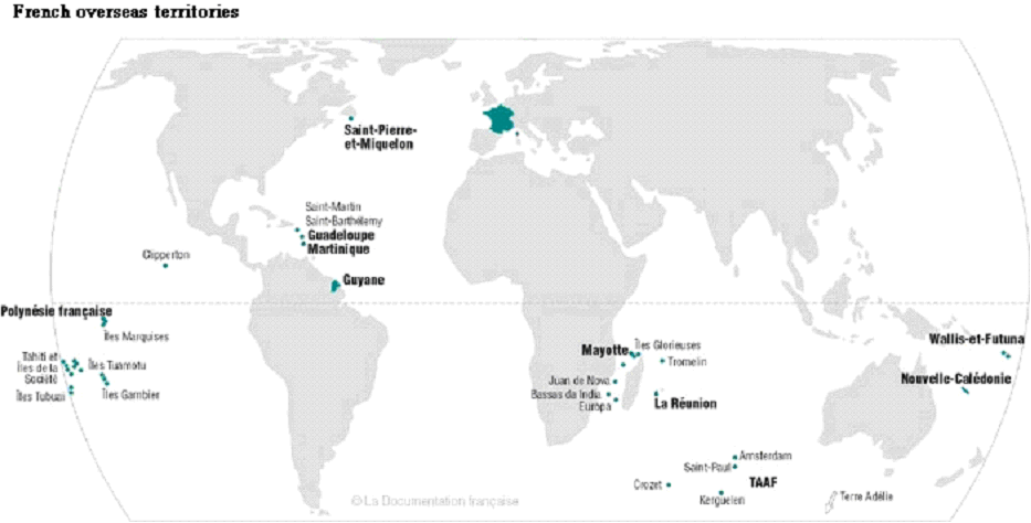
Via its overseas départements and territories, France is present in all of the world's oceans, which should encourage it to play a central role in the setting up of tsunami warning systems. In reality, once the initial shock provoked by the Sumatra catastrophe had faded away, the political will to take action soon followed suit, leaving the technical services on their own and without the necessary means to assume the commitments taken by France only just over two years ago.
A. A HIGH VULNERABILITY TO TSUNAMIS WHICH SHOULD INDUCE FRANCE TO MAKE A STRONG COMMITMENT
All French coasts are concerned by tsunamis; therefore, it is in the country's interest to develop an international warning system.
1. Important security stakes
a) A particularly high vulnerability due to its geography
France's Exclusive Economic Zones (ZEE) cover more than 10 million km² in the Atlantic, Indian and Pacific Oceans. Therefore, France is second only to the United States.
Conversely, this means France is particularly vulnerable to tsunamis.
Metropolitan France has 5,800 km of coastline. As regards its Mediterranean coast, the following events have been recorded:
- On 20 July 1564, an earthquake provoked an inundation in Antibes and caused damages in Nice.
- On 4 February 1808, an ebb and flow were observed in Marseilles following an earthquake.
- On 9 December 1818, an earthquake provoked violent waves in Antibes.
- On 23 February 1887, an earthquake in the Liguria Sea provoked a retreat of the sea followed by waves of up to 2 metres in Cannes and Antibes, inundating the beaches and causing material damages.
- On 16 October 1979, the collapse of a section of the Nice Airport generated waves 3 metres high in Antibes.
- On 21 May 2003, the tsunami generated by the Boumerdès earthquake in Algeria (with a magnitude of 6.8 on the Richter Scale) caused damages in several French harbours.
The last two events are symptomatic of the types of tsunami that could affect the French Riviera in the future.
Firstly, a landslide is liable to provoke a local tsunami, with a very short propagation time. In the case of the Nice Airport, the accident was undoubtedly caused by both the construction work and the zone's instability. Generally speaking, the Liguria Sea coast (from Fréjus to Menton for France) is deemed unstable and deep, resulting in a maximum risk level.
Secondly, the geodynamic context of the Mediterranean coast makes this a dangerous zone. An earthquake provoking a landslide or an underwater earthquake could generate a tsunami that would make the event even worse. Such an earthquake could occur in the Liguria Sea, where there are active faults. It could also occur in Algeria. The Boumerdès earthquake occurred on the border between the Eurasian Plate and the African Plate, in a region where the African Plate moves in a northwesterly direction against the Eurasian Plate, at a speed of a few millimetres per year. The relative displacement of the plate creates a tectonic environment favourable to high-magnitude earthquakes that could generate tsunamis several metres high, with very short propagation times (no more than one hour).
France also has more than 12,000 km of overseas coasts, in every ocean of the world. The tsunami risk is especially high in La Réunion, the Pacific and the West Indies.
Some 7 hours following the Sumatra earthquake of 26 December 2004, the tsunami had reached the coast of La Réunion with waves of up to 2.5 metres, causing nearly €500,000 worth of material damages.
In the Pacific, while the tsunami risk is not ignored in French Polynesia, up until now, it has nevertheless not been the subject of any monitoring programme in Wallis and Futuna and New Caledonia. However, several events testify to the reality of this risk in these two regions.
Tsunamis observed in New Caledonia
|
DATE |
PLACE OF ORIGIN |
REMARKS |
|
28.3.1875 |
Earthquake (8) Vanuatu |
Devastating tsunami in Lifou. |
|
4.10.1931 |
Earthquake (7.9) Solomon Islands |
1.5 m tsunami in Hienghene, boats capsized. |
|
19.7.1934 |
Earthquake (7.8) East Solomon Islands |
1.3 m tsunami in Hienghene, Touho. |
|
21.7.1934 |
Earthquake (7) East Solomon Islands |
Tsunami in Hienghene, Touho, Thio. |
|
1951 |
Exact date and origin unknown. |
Tsunami north of Ouvéa. |
|
1993 |
Earthquake (6.3) Futuna |
Local tsunami that did not cause any damage. |
|
1 April 2007 |
Earthquake (8.3) Solomon Islands |
Tsunami in Hienghene, Poindimié and Touho. |
Source: CEA, IOC
The tsunami history of the West Indies is still not well known; however, we do know that the Lisbon earthquake of 1755 generated 3 to 6-metre-high waves there. This region's seismicity is dominated by ruptures between the North Atlantic and Caribbean Plates, with the first sinking below the second at a speed of 2 cm per year. This region is also highly volcanic.
The past decade has been marked by several events:
· On 21 November 2004, an earthquake occurred off the coast of Guadeloupe, some ten kilometres south of Les Saintes. With a magnitude of 6.3, this was the strongest earthquake to have hit the archipelago since 1897. A "hollow" formed on the sea floor, inducing water movements that generated a tsunami with a propagation velocity of some 100 km/h. The water retreated by some 80 metres. Measurements taken by geologists a few weeks later on the neighbouring coasts showed, by the debris left by the tsunami, that the sea had risen several metres in certain locations along the southern coast of Les Saintes. Luckily, the tsunami caused only material damages.
· Successive collapses of the volcanic dome on the neighbouring island of Montserrat generated tsunamis on the coasts of Guadeloupe in 2003 (with a height of 8 m in Montserrat and 70 cm in Guadeloupe) and in 2006 (with waves of up to 1 m in Guadeloupe).
The Montserrat volcano's landslides have sent 200 million m3 of volcanic material into the sea since 1997. However, it has been demonstrated that other volcanoes in the West Indies have generated much larger landslides in the past. For example, Mount Pelée in Martinique sent several km3 of rock into the sea 100,000, 25,000 and 9,000 years ago. A simulation has shown that a new collapse of this volcano (of some 1 km3) would generate a wave 10 to 20 metres high in the region. As for Mount Soufrière in Guadeloupe, this volcano has collapsed every thousand years or so for the past 8,000 years, the last time being 400 years ago.
Finally, there is an active underwater volcano near Grenada, called "Kick'em Jenny", that could also have a devastating impact. This volcano is currently located 180 m below sea level, but should one day form a new island.
Densely populated coastlines
In addition, the high population density of the French coasts, due to their high level of urbanization and industrialization, renders these coasts very vulnerable. The following examples are revealing:
In 1999, the population density of metropolitan France's coastal areas was 272 inhabitants per km², compared to a national average of 108 inhabitants per km². In certain locations, this figure can rise to as high as 2,500 inhabitants per km² along the French Riviera in the Alpes-Maritimes département, which welcomes nearly 10 million tourists each year41 ( * ), with peaks of up to 750,000 tourists per day during the summer.
As for Tahiti, 30,000 persons can be found on the coastal roads leading into and out of Papeete between 6:30 and 8:30 a.m. every day. The island's oil depots are located at the harbours, and its airport and "Postal and Telecommunications Service" are both on the coast.
* 41 Taking into account the Principality of Monaco.